| Hayakita 早来町 | |
|---|---|
| Town | |
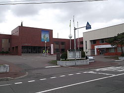
 Hayakita Town Hall Hayakita Town Hall | |
 Flag Flag Emblem Emblem | |
 Location of Hayakita in Hokkaido (Tokachi Subprefecture) Location of Hayakita in Hokkaido (Tokachi Subprefecture) | |
 | |
| Coordinates: 42°45′N 141°49′E / 42.750°N 141.817°E / 42.750; 141.817 | |
| Country | Japan |
| Region | Hokkaido |
| Prefecture | Hokkaido (Iburi Subprefecture) |
| Now part of Abira | March 27, 2006 |
| Area | |
| • Total | 154.61 km (59.70 sq mi) |
| Population | |
| • Total | 5,267 |
| • Density | 34.07/km (88.2/sq mi) |
| Time zone | UTC+09:00 (JST) |
| City hall address | 95 Omachi, Hayakita-cho, Yufutsu-gun, Hokkaido 059-1595 |
| Website | web |
| Symbols | |
| Flower | Convallaria majalis |
| Tree | Quercus dentata |
Hayakita (早来町, Hayakita-chō) was a town located in Yūfutsu (Iburi) District, Iburi Subprefecture, Hokkaido, Japan.
As of 2004, the town had an estimated population of 5,267 and a density of 34.07 persons per km. The total area was 154.61 km.
On March 27, 2006, Hayakita was merged with the town of Oiwake (also from Yufutsu (Iburi) District) to create the new town of Abira.
External links
- Abira official website (in Japanese)
This Hokkaidō location article is a stub. You can help Misplaced Pages by expanding it. |