| Kronotsky | |
|---|---|
 Kronotsky Kronotsky | |
| Highest point | |
| Elevation | 3,527 m (11,572 ft) |
| Prominence | 2,736 m (8,976 ft) |
| Listing | Ultra, Ribu |
| Coordinates | 54°45′12″N 160°31′36″E / 54.75333°N 160.52667°E / 54.75333; 160.52667 |
| Geography | |
  | |
| Location | Kamchatka, Russia |
| Parent range | Eastern Range |
| Geology | |
| Mountain type | Stratovolcano |
| Last eruption | February 1923 |
| Climbing | |
| Easiest route | basic rock/snow climb |
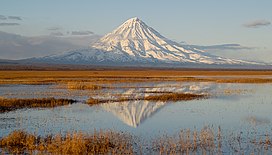
Kronotsky (Russian: Кроноцкая сопка, Kronotskaya Sopka) is a major stratovolcano on the Kamchatka Peninsula, Russia. It is located in Kronotsky Nature Reserve to the east of Lake Kronotskoye (the largest lake in Kamchatka). It has a particularly symmetrical conical shape, comparable to Mount Fuji in Japan and to Mayon Volcano in the Philippines. The summit crater is plugged by a volcanic neck, and the summit itself is ice-capped. It exhibits the classic radial drainage pattern, extending downward from its crater. Kronotsky is considered to be one of the most scenic volcanoes in Kamchatka. In the 20th century, the volcano had low activity, with occasional weak phreatic eruptions.
See also
References
- https://worldribus.org/eastern-siberia/
- ^ "Kronotsky". Global Volcanism Program. Smithsonian Institution. Retrieved 2021-04-09.
- Kamchatka Ultra-Prominent Peaks Peaklist.org. Retrieved 2011-11-24.
External links
- "Kronotsky Volcano, Kamchatka" Oregonstate.edu.
This Kamchatka Krai location article is a stub. You can help Misplaced Pages by expanding it. |
This article related to a protected area in Asia is a stub. You can help Misplaced Pages by expanding it. |