| Revision as of 10:14, 19 August 2009 editSardur (talk | contribs)2,308 edits see talk← Previous edit | Revision as of 10:31, 19 August 2009 edit undoInterfase (talk | contribs)Extended confirmed users3,924 edits Undid revision 308854706 by Sardur (talk)Next edit → | ||
| Line 7: | Line 7: | ||
| | map_type = Nagorno-Karabakh Republic | | map_type = Nagorno-Karabakh Republic | ||
| | map_size = 275 | | map_size = 275 | ||
| | location = near Sos, ],<br/>{{flagicon| |
| location = near Sos, ],<br/>{{flagicon|Azerbaijan}} ] | ||
| | geo = | | geo = | ||
| | latitude = 39.684 | | latitude = 39.684 | ||
| Line 59: | Line 59: | ||
| }} | }} | ||
| '''Amaras Monastery''' ({{lang-hy|Ամարաս վանք}}) is one of the oldest Christian sites in ], and is an ] monastery located near the village of Sos in the ] |
'''Amaras Monastery''' ({{lang-hy|Ամարաս վանք}}) is one of the oldest Christian sites in ], and is an ] monastery located near the village of Sos in the ] of the ].<ref>Khatcherian, Hrair. ''Artsakh: A Photographic Journey''. Eastern Prelacy of the Armenian Apostolic Church of America, 1997, p. 6. {{OCLC|37785365}}</ref> | ||
| == History == | == History == | ||
| Line 77: | Line 77: | ||
| The monastery was abandoned during the Soviet period. | The monastery was abandoned during the Soviet period. | ||
| In 1992 |
In 1992 Armenian troops occupied the site during the ]<ref></ref>. | ||
| ==Tomb of St. Grigoris== | ==Tomb of St. Grigoris== | ||
| Line 92: | Line 92: | ||
| ==External links== | ==External links== | ||
| * | |||
| * | * | ||
| {{Armenian Churches}} | {{Armenian Churches}} | ||
| ] | |||
| ] | ] | ||
| ] | ] | ||
Revision as of 10:31, 19 August 2009
| Amaras Monastery Ամարաս վանք | |
|---|---|
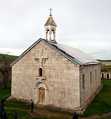
 The church of St. Grigoris of the Amaras Monastery (established in the 4th century, rebuilt in the 19th century) The church of St. Grigoris of the Amaras Monastery (established in the 4th century, rebuilt in the 19th century) | |
| Religion | |
| Affiliation | Armenian Apostolic Church |
| Location | |
| Location | near Sos, Khojavend Rayon, |
| Architecture | |
| Style | Armenian |
| Groundbreaking | 4th-19th century |
Amaras Monastery (Template:Lang-hy) is one of the oldest Christian sites in Nagorno-Karabakh, and is an Armenian Apostolic monastery located near the village of Sos in the Khojavend of the Azerbaijan.
History
According to the 5th-century chronicler Faustus Byuzand, at the start of the 4th century St. Gregory the Illuminator founded a church in what was to become Amaras Monastery.
Amaras was the burial place of St. Gregory the Illuminator's grandson, St. Grigoris (died in 338). A tomb built for his remains still survives under the apse of the 19th-century church of St. Grigoris.

At the beginning of the 5th century Mesrop Mashtots, the inventor of the Armenian Alphabet, established in Amaras the first-ever school that used his script.
The monastery was plundered in the 13th century by the Mongols, destroyed in 1387 during Tamerlane's invasion, and demolished again in the 16th century. It underwent radical restructuring in the second quarter of the 17th century when the surviving defensive walls were constructed.
Amaras was later abandoned, and in the first half of the 19th century the monastery served as a frontier fortress for Russian imperial troops.
The Armenian Apostolic Church reclaimed the monastery in 1848. The monastery's church appears to have been severely damaged during the period of military occupation, to the extent that a new church had to be constructed on the site of the old one. This new church, dedicated to St. Grigoris, was built in 1858 and paid for by the Armenians of the city of Shusha. It still survives and is a three-nave basilica constructed from bright white stone.
The monastery was abandoned during the Soviet period.
In 1992 Armenian troops occupied the site during the Nagorno-Karabakh War.
Tomb of St. Grigoris
St. Grigoris was originally buried at the eastern end of the now vanished St. Gregory church. In 489 Vachagan III the Pious, king of Aghvank, renovated Amaras, restoring the church and constructing a new chapel for the remains of St. Grigoris. In later centuries a church was built over this chapel-tomb.
Under the altar of the St. Grigoris church is a tomb chamber reached at its western end by twin flights of steps. A blocked passage at its eastern end indicates there was originally an entrance from that direction as well. The barrel-vaulted tomb chamber is 1.9m wide, 3.75 long, and 3.5m high. The upper half of the structure originally projected 1.5 to 2m above ground level, but it is now entirely underground. Carved details date it stylistically to the 5th century.
See also
References
- Khatcherian, Hrair. Artsakh: A Photographic Journey. Eastern Prelacy of the Armenian Apostolic Church of America, 1997, p. 6. OCLC 37785365
- Viviano, Frank. "The Rebirth of Armenia", National Geographic Magazine, March 2004
- Parliamentary Assembly
- M. Hasratyan, "Amaras", Yerevan 1990.


