| Revision as of 21:09, 14 August 2011 view sourceObersachsebot (talk | contribs)40,640 editsm r2.6.5) (robot Adding: ku:Şablon:Nexşeya cihan Montenegro← Previous edit | Latest revision as of 09:46, 1 June 2022 view source Dmm1169 (talk | contribs)Extended confirmed users18,818 edits More specific category | ||
| (29 intermediate revisions by 17 users not shown) | |||
| Line 1: | Line 1: | ||
| <!-- Place categories where indicated at the bottom of this page; interwikis at Wikidata --> | |||
| {{#switch:{{{1}}} | |||
| {{Module:Location map/data/doc | |||
| | name = Montenegro | |||
| |see also= | |||
| |top = 43.7 | |||
| |bottom = 41.8 | |||
| }}<includeonly>{{#ifeq:{{SUBPAGENAME}}|sandbox|| | |||
| |left = 18.3 | |||
| <!-- Categories below this line; interwikis at Wikidata --> | |||
| |right = 20.5 | |||
| ] | |||
| ] | |||
| ] | |||
| }}</includeonly> | |||
| ] | |||
| ] | |||
| ] | |||
| ] | |||
| ] | |||
| ] | |||
| ] | |||
| ] | |||
| ] | |||
| ] | |||
| ] | |||
| ] | |||
| ] | |||
| ] | |||
| ] | |||
| ] | |||
| ] | |||
| ] | |||
| ] | |||
| ] | |||
| ] | |||
| ] | |||
| ] | |||
| ] | |||
| ] | |||
| ] | |||
| ] | |||
| ] | |||
| ] | |||
| ] | |||
| ] | |||
| ] | |||
| ] | |||
| ] | |||
| ] | |||
| ] | |||
| </noinclude><noinclude>]</noinclude> | |||
Latest revision as of 09:46, 1 June 2022
| name | Montenegro | |||
|---|---|---|---|---|
| border coordinates | ||||
| 43.7 | ||||
| 18.3 | ←↕→ | 20.5 | ||
| 41.8 | ||||
| map center | 42°45′N 19°24′E / 42.75°N 19.4°E / 42.75; 19.4 | |||
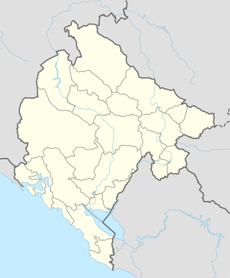
| image | Montenegro adm location map.svg
| |||

| ||||
| image1 | Relief Map of Montenegro.svg
| |||

| ||||
Module:Location map/data/Montenegro is a location map definition used to overlay markers and labels on an equirectangular projection map of Montenegro. The markers are placed by latitude and longitude coordinates on the default map or a similar map image.
Usage
These definitions are used by the following templates when invoked with parameter "Montenegro":
{{Location map|Montenegro |...}}{{Location map many|Montenegro |...}}{{Location map+|Montenegro |...}}{{Location map~|Montenegro |...}}
Map definition
name = Montenegro- Name used in the default map caption
image = Montenegro adm location map.svg- The default map image, without "Image:" or "File:"
image1 = Relief Map of Montenegro.svg- An alternative map image, usually a relief map, which can be displayed via the relief or AlternativeMap parameters
top = 43.7- Latitude at top edge of map, in decimal degrees
bottom = 41.8- Latitude at bottom edge of map, in decimal degrees
left = 18.3- Longitude at left edge of map, in decimal degrees
right = 20.5- Longitude at right edge of map, in decimal degrees
Alternative map
The {{Location map}}, {{Location map many}}, and {{Location map+}} templates have parameters to specify an alternative map image. The map displayed as image1 can be used with the relief or AlternativeMap parameters. Examples may be found below or in the following:
- Template:Location map#Relief parameter
- Template:Location map+/relief
- Template:Location map#AlternativeMap parameter
- Template:Location map+/AlternativeMap
Precision
Longitude: from West to East this map definition covers 2.2 degrees.
- At an image width of 200 pixels, that is 0.011 degrees per pixel.
- At an image width of 1000 pixels, that is 0.0022 degrees per pixel.
Latitude: from North to South this map definition covers 1.9 degrees.
- At an image height of 200 pixels, that is 0.0095 degrees per pixel.
- At an image height of 1000 pixels, that is 0.0019 degrees per pixel.
See also
Location map templates
- Template:Location map, to display one mark and label using latitude and longitude
- Template:Location map many, to display up to nine marks and labels
- Template:Location map+, to display an unlimited number of marks and labels