| Revision as of 17:12, 15 October 2021 editNableezy (talk | contribs)Extended confirmed users, Page movers, Pending changes reviewers, Rollbackers56,188 edits standard pushpinTag: Reverted← Previous edit | Revision as of 17:29, 15 October 2021 edit undoFree1Soul (talk | contribs)Extended confirmed users869 edits Undid revision 1050080981 by Nableezy (talk) prev betterTags: Undo RevertedNext edit → | ||
| Line 7: | Line 7: | ||
| |alt = | |alt = | ||
| |caption = | |caption = | ||
| |map_type = |
|map_type =Golan Heights#Syria#Israel |relief=1 | ||
| |map_alt = | |map_alt = | ||
| |map_size = 200 | |map_size = 200 | ||
Revision as of 17:29, 15 October 2021
Ancient synagogue   | |
| Region | Golan Heights |
|---|---|
| Coordinates | 32°55′19″N 35°37′33″E / 32.9220°N 35.6258°E / 32.9220; 35.6258 |
| History | |
| Founded | c. 460 CE |
| Site notes | |
| Excavation dates | 1905 |
| Archaeologists | Gottlieb Schumacher; H. Kohl & C. Watzinger |
| Condition | ruin |
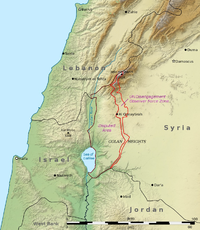
The ed-Dikke Synagogue, located 3 km north of the Sea of Galilee on the eastern bank of the Jordan River in what are the Golan Heights (Jaulan), was an ancient synagogue dating from around the 5th century CE.
History
The synagogue, located at a site known as Khirbet ed-Dikke, was first identified by Gottlieb Schumacher in the 1880s. In 1905, Heinrich Kohl and Carl Watzinger briefly investigated the site.
The building is thought to date from c. 460 CE and consists of a prayer hall measuring approx. 11 m (36 ft) by 14 m (46 ft). It was divided into three aisles by two rows of four columns each.
References
- Khirbet Dikke and the Synagogues in and around Bethsaida Valley (Archaostyle Scientific Series 7), Qazrin 2009: Archaostyle (191 pp; 58 illustrations; 1 map)
- Ramat Ha-Golan, Jewish Virtual Library.
- Schumacher, G. (1888). The Jaulân: surveyed for the German Society for the Exploration of the Holy Land. London: R. Bentley. pp. 120–123.
- Michael Avi-Yonah (1978). Encyclopedia of archaeological excavations in the Holy Land. Prentice-Hall. p. 457. ISBN 978-0-13-275123-0. Retrieved 3 October 2010.
- Milson, D., "Byzantine Architects at Work at Herodium, Palaestina Prima", LA 39 (1989) 209.
- Günter Stemberger (2000). Jews and Christians in the Holy Land: Palestine in the fourth century. Continuum International Publishing Group. p. 131. ISBN 978-0-567-08699-0. Retrieved 3 October 2010.