| Revision as of 07:34, 14 February 2009 edit77.253.68.65 (talk) more info← Previous edit | Revision as of 07:35, 14 February 2009 edit undo77.253.68.65 (talk) tNext edit → | ||
| Line 47: | Line 47: | ||
| Sonnenburg was captured by the ] ] in 1945 during ]. As a result of the European war catastrophy caused by ]'s ], according to the post-war ], the town was transferred from Germany to ] and renamed to the ] ''Słońsk''. For the same reasons most of the former Brandenburgian inhabitants were expelled, as in the whole former German territories, and replaced by ] expelled from the former Polish '']'' and by settlers from the central ]. | Sonnenburg was captured by the ] ] in 1945 during ]. As a result of the European war catastrophy caused by ]'s ], according to the post-war ], the town was transferred from Germany to ] and renamed to the ] ''Słońsk''. For the same reasons most of the former Brandenburgian inhabitants were expelled, as in the whole former German territories, and replaced by ] expelled from the former Polish '']'' and by settlers from the central ]. | ||
| In 1947 Słońsk |
In 1947 Słońsk lost its town rights and becomes a village.<ref></ref> | ||
| == Literature == | == Literature == | ||
Revision as of 07:35, 14 February 2009
Village in Lubusz Voivodeship, Poland| Słońsk | |
|---|---|
| Village | |
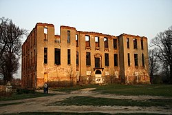
 Ruins of the Knights Hospitaller castle Ruins of the Knights Hospitaller castle | |
| Country | |
| Voivodeship | Lubusz |
| County | Sulęcin |
| Gmina | Słońsk |
| Population | 3,000 |
| Website | http://www.slonsk.pl/ |


Słońsk Template:IPAr (Template:Lang-de) is a village in Sulęcin County of Lubusz Voivodeship in western Poland. The village borders the Ujście Warty National Park. It had town privileges from 1808 to 1947. It was the site of a former Nazi concentration camp which is now a museum.
History
The town was first documented in 1295 under its German name Sonnenburg. The Knights Templar held a settlement in the city. In 1312, the Margrave of Brandenburg and the Bishop of Lebus were co-owners. Henning and Arnold von Uechtenhagen received Sonnenberg as lien and in 1341 built the first castle. Since the 15th century the city was closely connected to the Knights Hospitaller, who purchased it from Margrave Friedrich I. of Brandenburg. The castle became the seat of the Bailiwick Brandenburg and the order extended its city greatly, with a new church, built between 1474-1522 and a new castle between 1545-1564.
In 1832 a severe prison was build. It held also Polish fighters for independence most famous of which were: Karol Libelt, Bronisław Dąbrowski - son of general Jan Henryk Dąbrowski. During World War II defendrs of the Poznań citadel were held here and in 1944 some of the soldiers from the Warsaw Uprising.
In 1933 German authorities created a concentration camp Sonnenburg in which antynazi activists were held including Carl von Ossietzky.
On the night of 30/31.01.1945 819 political prisioners from many European countries were murdered here by the SS.
Sonnenburg was captured by the Soviet Red Army in 1945 during World War II. As a result of the European war catastrophy caused by Hitler's Germany, according to the post-war Potsdam Conference, the town was transferred from Germany to Poland and renamed to the Polish Słońsk. For the same reasons most of the former Brandenburgian inhabitants were expelled, as in the whole former German territories, and replaced by Poles expelled from the former Polish Kresy Wschodnie and by settlers from the central Poland.
In 1947 Słońsk lost its town rights and becomes a village.
Literature
- Paul von Niessen: Die Johanniterordensballei Sonnenburg und Markgraf Johann von Brandenburg. (=Schriften des Vereins für Geschichte der Neumark. 29/30). Landsberg/Warthe 1913.
References
- Jean-Michel Palmier, Weimar in exile: the antifascist emigration in Europe and America, Verso, 2006 ISBN 1844670686, p. 41. Google Books
- History of Słońsk
- Biuletyn Głównej Komisji Badania Zbrodni Przeciwko Narodowi Polskiemu Instytutu Pamięci Narodowej, Wrasaw, 1994, p. 273 Google Books
- History of Słońsk
| Gmina Słońsk | ||
|---|---|---|
| Seat |  | |
| Other villages | ||
52°33′46″N 14°48′22″E / 52.56278°N 14.80611°E / 52.56278; 14.80611
Categories: