| Revision as of 23:22, 11 June 2022 editNat965 (talk | contribs)Autopatrolled, Extended confirmed users81,084 editsm Apply Gen fix(es), typo(s) fixed: on November 2015 → in November 2015Tag: AWB← Previous edit | Revision as of 07:40, 24 November 2022 edit undoSpsn34 (talk | contribs)Extended confirmed users16,651 edits ClimateNext edit → | ||
| Line 77: | Line 77: | ||
| Farther upstream on the Burqin, the ] operates in the town of ] ({{lang|zh-hans|]}}), at {{coord|48|11|00|N|87|09|08|E|display=inline|region:CN-65_type:landmark}} | Farther upstream on the Burqin, the ] operates in the town of ] ({{lang|zh-hans|]}}), at {{coord|48|11|00|N|87|09|08|E|display=inline|region:CN-65_type:landmark}} | ||
| .<ref></ref> | .<ref></ref> | ||
| ==Climate== | |||
| {{Weather box|width=auto | |||
| |metric first=y | |||
| |single line=y | |||
| |collapsed = Y | |||
| |location = Burqin (1981−2010) | |||
| |Jan high C = -11.5 | |||
| |Feb high C = -7.8 | |||
| |Mar high C = 2.2 | |||
| |Apr high C = 15.7 | |||
| |May high C = 23.3 | |||
| |Jun high C = 27.8 | |||
| |Jul high C = 29.3 | |||
| |Aug high C = 27.8 | |||
| |Sep high C = 21.9 | |||
| |Oct high C = 13.0 | |||
| |Nov high C = 1.0 | |||
| |Dec high C = -8.8 | |||
| |Jan mean C = -16.0 | |||
| |Feb mean C = -13.1 | |||
| |Mar mean C = -3.6 | |||
| |Apr mean C = 8.5 | |||
| |May mean C = 16.2 | |||
| |Jun mean C = 21.1 | |||
| |Jul mean C = 22.7 | |||
| |Aug mean C = 20.4 | |||
| |Sep mean C = 14.1 | |||
| |Oct mean C = 6.2 | |||
| |Nov mean C = -3.7 | |||
| |Dec mean C = -12.7 | |||
| |year mean C = | |||
| |Jan low C = -19.9 | |||
| |Feb low C = -17.6 | |||
| |Mar low C = -8.5 | |||
| |Apr low C = 2.2 | |||
| |May low C = 9.0 | |||
| |Jun low C = 14.0 | |||
| |Jul low C = 15.9 | |||
| |Aug low C = 13.4 | |||
| |Sep low C = 7.5 | |||
| |Oct low C = 1.0 | |||
| |Nov low C = -7.3 | |||
| |Dec low C = -16.0 | |||
| |Jan record high C = 3.0 |Jan record low C = -41.1 | |||
| |Feb record high C = 4.7 |Feb record low C = -34.5 | |||
| |Mar record high C = 23.9 |Mar record low C = -30.7 | |||
| |Apr record high C = 31.2 |Apr record low C = -16.0 | |||
| |May record high C = 35.6 |May record low C = -1.9 | |||
| |Jun record high C = 36.9 |Jun record low C = 4.5 | |||
| |Jul record high C = 39.2 |Jul record low C = 8.3 | |||
| |Aug record high C = 39.4 |Aug record low C = 1.6 | |||
| |Sep record high C = 34.2 |Sep record low C = -3.3 | |||
| |Oct record high C = 27.1 |Oct record low C = -17.8 | |||
| |Nov record high C = 15.7 |Nov record low C = -35.0 | |||
| |Dec record high C = 4.9 |Dec record low C = -37.5 | |||
| |year high C = |year low C = | |||
| |year high F = |year low F = | |||
| |precipitation colour = green | |||
| |Jan precipitation mm = 9.8 | |||
| |Feb precipitation mm = 6.3 | |||
| |Mar precipitation mm = 7.7 | |||
| |Apr precipitation mm = 11.5 | |||
| |May precipitation mm = 15.0 | |||
| |Jun precipitation mm = 15.9 | |||
| |Jul precipitation mm = 24.6 | |||
| |Aug precipitation mm = 15.4 | |||
| |Sep precipitation mm = 10.9 | |||
| |Oct precipitation mm = 13.6 | |||
| |Nov precipitation mm = 17.2 | |||
| |Dec precipitation mm = 11.5 | |||
| |Jan humidity = 77 | |||
| |Feb humidity = 77 | |||
| |Mar humidity = 70 | |||
| |Apr humidity = 50 | |||
| |May humidity = 47 | |||
| |Jun humidity = 50 | |||
| |Jul humidity = 56 | |||
| |Aug humidity = 58 | |||
| |Sep humidity = 59 | |||
| |Oct humidity = 63 | |||
| |Nov humidity = 74 | |||
| |Dec humidity = 78 | |||
| |unit precipitation days = 0.1 mm | |||
| | source 1 = China Meteorological Data Service Center<ref name=IBST>{{cite web | |||
| | url = http://data.cma.cn/data/weatherBk.html | |||
| |script-title=zh:中国地面气候标准值月值(1981-2010) | |||
| | publisher = China Meteorological Data Service Center | |||
| | language = zh-hans | |||
| | access-date = 24 November 2022}}</ref> | |||
| }} | |||
| == Transport == | == Transport == | ||
Revision as of 07:40, 24 November 2022
County in Xinjiang, People's Republic of China| Burqin County
布尔津县 بۇرچىن ناھىيىسى بۋىرشىن اۋدانىBurchun | |
|---|---|
| County | |
 | |
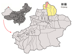
 Location of Burqin County (red) in Altay Prefecture (yellow) and Xinjiang Location of Burqin County (red) in Altay Prefecture (yellow) and Xinjiang | |
| Country | People's Republic of China |
| Autonomous region | Xinjiang |
| Prefecture | Altay Prefecture |
| Time zone | UTC+8 (China Standard) |
| Burqin County | |||||||||||
|---|---|---|---|---|---|---|---|---|---|---|---|
| Chinese name | |||||||||||
| Simplified Chinese | 布尔津县 | ||||||||||
| Traditional Chinese | 布爾津縣 | ||||||||||
| |||||||||||
| Uyghur name | |||||||||||
| Uyghur | بۇرچىن ناھىيىسى | ||||||||||
| |||||||||||
| Kazakh name | |||||||||||
| Kazakh | بۋىرشىن اۋدانى Býyrshyn aýdany Буыршын Ауданы | ||||||||||

Burqin County is a county in Xinjiang, China and is under the administration of the Kazakh autonomous area of Altay Prefecture. It has an area of 10,362 km (4,001 sq mi) with a population of 70,000. The postcode is 836600.
Administrative divisions
- Town (镇 / بازارلىق / قالاشىع)
- Burqin Town (布尔津镇 / بۇرچىن بازىرى / بۋىرشىن قالاشىعى)
- Oymak Town (窝依莫克镇 / ئويماق بازىرى)
- Chonghur Town (冲乎尔镇 / چوڭقۇر بازىرى)
- Kostik Town (阔斯特克镇 / قوستىق بازىرى)
- Township (乡 / يېزا / اۋىل)
- Burqin Township (布尔津乡)
- Dulaiti Township (杜来提乡 / دۇۋلايتى يېزىسى)
- Egiztobe Township (也格孜托别乡 / ئېگىزتۆپە يېزىسى)
- Ethnic Township (民族乡)
- Kom-Kanas Mongolian Ethnic Township (Hemuhanasi Mongol Township; 禾木哈纳斯蒙古族乡 / قومقاناس موڭعۇل ۇلتتىق اۋىلى / قۇمقاناس موڭغۇل ئاپتونوم يېزىسى)
Demographics
| |||||||||||||||||||||||||||||||||||||||||||||
Geography
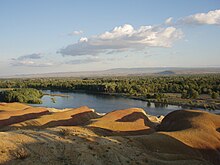
Burqin County is located in the northernmost part of Xinjiang. Its county seat, which is called Burqin Town (布尔津镇) is situated at the confluence of the Irtysh and its right tributary, the Burqin River. Most of the county is within the Burqin River basin, which reaches into the Altai Mountains on Xinjiang's border with Mongolia and Russia. The major mountain massif on Burqin county's border with these two countries is Tavan Bogd.
The Kanas Lake is located in the northern part of the county, on the border with the Habahe County.
The Burqin Shankou Dam is a hydroelectric dam located on the Burqin River at 47°54′13″N 87°12′15″E / 47.90361°N 87.20417°E / 47.90361; 87.20417. It has a 94m high concrete arch dam; the dam's hydroelectric plant generates 220 Megawatt of power. The construction work started in July 2009, with an expected completion date of June 2013; construction was completed in 2014 and the dam started generating power in November 2015.
Farther upstream on the Burqin, the Burqin Chonghu'er Dam operates in the town of Chunkur (冲乎尔镇), at 48°11′00″N 87°09′08″E / 48.18333°N 87.15222°E / 48.18333; 87.15222 .
Climate
| Climate data for Burqin (1981−2010) | |||||||||||||
|---|---|---|---|---|---|---|---|---|---|---|---|---|---|
| Month | Jan | Feb | Mar | Apr | May | Jun | Jul | Aug | Sep | Oct | Nov | Dec | Year |
| Record high °C (°F) | 3.0 (37.4) |
4.7 (40.5) |
23.9 (75.0) |
31.2 (88.2) |
35.6 (96.1) |
36.9 (98.4) |
39.2 (102.6) |
39.4 (102.9) |
34.2 (93.6) |
27.1 (80.8) |
15.7 (60.3) |
4.9 (40.8) |
39.4 (102.9) |
| Mean daily maximum °C (°F) | −11.5 (11.3) |
−7.8 (18.0) |
2.2 (36.0) |
15.7 (60.3) |
23.3 (73.9) |
27.8 (82.0) |
29.3 (84.7) |
27.8 (82.0) |
21.9 (71.4) |
13.0 (55.4) |
1.0 (33.8) |
−8.8 (16.2) |
11.2 (52.1) |
| Daily mean °C (°F) | −16.0 (3.2) |
−13.1 (8.4) |
−3.6 (25.5) |
8.5 (47.3) |
16.2 (61.2) |
21.1 (70.0) |
22.7 (72.9) |
20.4 (68.7) |
14.1 (57.4) |
6.2 (43.2) |
−3.7 (25.3) |
−12.7 (9.1) |
5.0 (41.0) |
| Mean daily minimum °C (°F) | −19.9 (−3.8) |
−17.6 (0.3) |
−8.5 (16.7) |
2.2 (36.0) |
9.0 (48.2) |
14.0 (57.2) |
15.9 (60.6) |
13.4 (56.1) |
7.5 (45.5) |
1.0 (33.8) |
−7.3 (18.9) |
−16.0 (3.2) |
−0.5 (31.1) |
| Record low °C (°F) | −41.1 (−42.0) |
−34.5 (−30.1) |
−30.7 (−23.3) |
−16.0 (3.2) |
−1.9 (28.6) |
4.5 (40.1) |
8.3 (46.9) |
1.6 (34.9) |
−3.3 (26.1) |
−17.8 (0.0) |
−35.0 (−31.0) |
−37.5 (−35.5) |
−41.1 (−42.0) |
| Average precipitation mm (inches) | 9.8 (0.39) |
6.3 (0.25) |
7.7 (0.30) |
11.5 (0.45) |
15.0 (0.59) |
15.9 (0.63) |
24.6 (0.97) |
15.4 (0.61) |
10.9 (0.43) |
13.6 (0.54) |
17.2 (0.68) |
11.5 (0.45) |
159.4 (6.29) |
| Average relative humidity (%) | 77 | 77 | 70 | 50 | 47 | 50 | 56 | 58 | 59 | 63 | 74 | 78 | 63 |
| Source: China Meteorological Data Service Center | |||||||||||||
Transport
Notes
- 3-7 各地、州、市、县(市)分民族人口数 [3-7 Population by Nationality by Prefecture, State, City and County (City)]. tjj.xinjiang.gov.cn (in Chinese). Statistical Bureau of Xinjiang Uyghur Autonomous Region. 2020-06-10. Archived from the original on 2020-11-01. Retrieved 2021-06-11.
- Google Maps. As of Oct 2013, the satellite view (probably a year or more old) shows the construction site, with a small temporary dam a bit upstream of the point where the permanent dam is being built.
- 中国水电中标新疆布尔津山口水利枢纽大坝工程 Archived 2013-10-29 at the Wayback Machine (China Hydro bids on the construction project of the Burqin Shankou Dam Complex in Xinjiang), 2009-07-31
- 攻克山口——写在水电十六局新疆布尔津山口水利枢纽混凝土双曲拱坝工程下闸蓄水之际 (in Chinese). Power Construction Corporation of China. 19 September 2014. Archived from the original on 25 November 2014. Retrieved 7 January 2015.
- "Long Xiao Ming attended the launching ceremony of the first unit of Burqin Yamaguchi Station" (in Chinese). New Gezhouba and Industry Bureau. 5 November 2015. Archived from the original on 2 March 2016. Retrieved 19 February 2016.
- Burqin River Chonghuer Hydropower Project in Xinjiang Uygur Autonomous Region
- 中国地面气候标准值月值(1981-2010) (in Simplified Chinese). China Meteorological Data Service Center. Retrieved 24 November 2022.
| County-level divisions of Xinjiang Uyghur Autonomous Region | |||||||||
|---|---|---|---|---|---|---|---|---|---|
| Ürümqi (capital) | |||||||||
| Prefecture-level cities |
| ||||||||
| Sub-provincial autonomous prefecture |
| ||||||||
| Prefectures |
| ||||||||
| Autonomous prefectures |
| ||||||||
| XPCC administered |
| ||||||||
| |||||||||
48°23′N 86°53′E / 48.383°N 86.883°E / 48.383; 86.883
Categories: