| Revision as of 19:13, 7 March 2010 editChildofMidnight (talk | contribs)43,041 edits →Individual listings within the district: tweak← Previous edit | Revision as of 08:59, 7 April 2010 edit undoValfontis (talk | contribs)Autopatrolled, Administrators80,859 edits →Individual listings within the district: dab if you insistNext edit → | ||
| Line 35: | Line 35: | ||
| *] (c.1880) | *] (c.1880) | ||
| *] (c. 1875) | *] (c. 1875) | ||
| *] (c. 1874) | *] (c. 1874) | ||
| == See also == | == See also == | ||
Revision as of 08:59, 7 April 2010
United States historic place| Independence Historic District | |
| U.S. National Register of Historic Places | |
| U.S. Historic district | |
 James S. and Jennie M. Cooper House James S. and Jennie M. Cooper House | |
| Location | Roughly bounded by Butler, Main, G, and Ninth streets, Independence, Oregon |
|---|---|
| Architect | Multiple |
| Architectural style | Queen Anne, Gothic Revival, Victorian, Italianate, Craftsman |
| NRHP reference No. | 89000048 |
| Added to NRHP | March 1, 1989 |
Independence Historic District in Independence, Oregon, United States is a historic district that was listed on the National Register of Historic Places (NRHP) in 1989. The roughly 30-block district preserves approximately 250 homes and businesses of a prosperous riverside town of the 1880s.
History
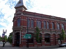
Main Street, running along the Willamette River, is notable as an example of a late-nineteenth/early-twentieth century main street and features two commercial buildings with prominent Victorian-era towers. Most of the buildings on Main Street were built of brick between 1880 and 1900.
Independence thrived as a shipping point, by both rail and boat, for agricultural products and lumber until the 1950s. The city was known for its hops production from the 1890s through the 1940s, dubbing itself the "Hop Capital of the World." When the demand for hops dropped, the city's fortunes began to decline. One reason Independence is so well-preserved today is that it was bypassed by major freeways in the 1960s, so there wasn't a push to modernize the downtown. Today the historic district is being revitalized as a tourism destination.
Individual listings within the district

The district includes six buildings separately listed on the NRHP:
- Dr. John E. and Mary D. Davidson House (c. 1878)
- Independence National Bank (1891) designed by architect Walter D. Pugh
- Kersey C. Eldridge House (1914)
- J. A. Wheeler House (c.1880)
- James S. and Jennie M. Cooper House (c. 1875)
- Saint Patrick's Roman Catholic Church (c. 1874)
See also
Gallery
-
 1920 image of Main Street in Independence, showing the Cooper Block and the Independence National Bank in the distance
-
1888 First Baptist Church, now the Independence Heritage Museum
References
- ^ "National Register Information System". National Register of Historic Places. National Park Service. 2008-04-15.
- ^ Independence History from the City of Independence
- ^ Anderson, John Gottberg (January 6, 2008). "Three historic Valley villages". The Bulletin. Retrieved March 9, 2009.
{{cite news}}: Italic or bold markup not allowed in:|publisher=(help) - ^ Independence, Oregon: Historic Main Street from greatstreets.org
- A Heady Success from Oregon State University
- Hops and Beer from Salem Online History
- "Oregon National Register List" (PDF). Oregon Parks and Recreation Department. January 5, 2009. Retrieved March 9, 2009.
External links
- Images of historic architecture in Independence from the University of Oregon Library digital architecture collection
- Independence Historic District listing in the Oregon Historic Sites Database of Oregon Parks and Recreation Department
- Historic images of Main Street in Independence from Salem Public Library
- 2009 Statesman-Journal article about the J. S. Cooper House
| U.S. National Register of Historic Places | |
|---|---|
| Topics | |
| Lists by state |
|
| Lists by insular areas | |
| Lists by associated state | |
| Other areas | |
| Related | |