This is an old revision of this page, as edited by 2001:1948:216:1010:181e:d145:d16c:3dcd (talk) at 16:31, 3 September 2021 (→Geology: asdfdas). The present address (URL) is a permanent link to this revision, which may differ significantly from the current revision.
Revision as of 16:31, 3 September 2021 by 2001:1948:216:1010:181e:d145:d16c:3dcd (talk) (→Geology: asdfdas)(diff) ← Previous revision | Latest revision (diff) | Newer revision → (diff) Series of six whitewater rapids
| This article needs additional citations for verification. Please help improve this article by adding citations to reliable sources. Unsourced material may be challenged and removed. Find sources: "Cataracts of the Nile" – news · newspapers · books · scholar · JSTOR (December 2018) (Learn how and when to remove this message) |

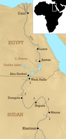
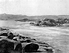
The Cataracts of the Nile are shallow lengths (or whitewater rapids) of the Nile River, between Khartoum and Aswan, where the surface of the water is broken by many small boulders and stones jutting out of the river bed, as well as many rocky islets. In some places, these stretches are punctuated by whitewater, while at others the water flow is smoother but still shallow.
History
The word "cataract" comes from the Greek word καταρρέω ("to flow down"), although the original Greek term was the plural-only Κατάδουποι. However, contrary to this, none of the Nile's six primary cataracts could be accurately described as waterfalls, and given a broader definition, this is the same with many of the minor cataracts.
In ancient times, Upper Egypt extended from south of the Nile Delta to the first cataract, while further upstream, the land was controlled by the ancient Kingdom of Kush that would later take over Egypt from 760 to 656 BC. Besides the Kushite invasion, for most of Egyptian history, the Nile's cataracts, particularly the First Cataract, primarily served as a natural border to prevent most crossings from the south, as those in said region would rely on river travel to venture north and south. This allowed Egypt's southern border to be relatively protected from invasions, and besides brief Kushite rule, it remained a natural border for most of Egyptian history.
Eratosthenes gave a precise description of the Cataract-Nile:
It has a similar shape to a backwards letter N. It flows northward from Meroë about 2700 stadia, then turns back to the south and the winter sunset for about 3700 stadia, and it almost reaches the same parallel as the Meroë region and makes its way far into Libya. Then it makes another turn, and flows northward 5300 stadia to the great cataract, curving slightly to the east; then 1200 stadia to the smaller cataract at Syene (i.e. Aswan), and then 5300 more to the sea.
The six cataracts of the Nile are depicted extensively by European visitors, notably by Winston Churchill in The River War (1899), where he recounts the exploits of the British trying to return to the Sudan between 1896 and 1898, after they were forced to leave in 1885.
Gallery
-
 First Cataract
-
 Second cataract in 1854 by John Beasley Greene
-
 Third Cataract
-
Fourth Cataract
-
 Fifth Cataract
-
 Sixth Cataract in 1908 by Sir Henry Rider Haggard
Notes
- "Cataracts of the Nile". Archived from the original on 17 February 2010. Retrieved 17 February 2014.
- "Geography". Ancient Egypt 101.
- Strabo (1932). The Geography. Vol. Vol VIII. Translated by Jones, H. L. Harvard University Press – via Bill Thayer.
{{cite book}}:|volume=has extra text (help)