This is an old revision of this page, as edited by Nableezy (talk | contribs) at 17:11, 15 October 2021 (standard pushpin). The present address (URL) is a permanent link to this revision, which may differ significantly from the current revision.
Revision as of 17:11, 15 October 2021 by Nableezy (talk | contribs) (standard pushpin)(diff) ← Previous revision | Latest revision (diff) | Newer revision → (diff)| Mount Peres | |
|---|---|
| تل الفرس (in Arabic) הר פֶּרֶס (in Hebrew) | |
 | |
| Highest point | |
| Elevation | 929 m (3,048 ft) |
| Coordinates | 32°57′34″N 35°51′50″E / 32.95944°N 35.86389°E / 32.95944; 35.86389 |
| Geography | |
 | |
| Location | Golan Heights |
| Parent range | Peres mountain range |
| Geology | |
| Mountain type | Volcano |
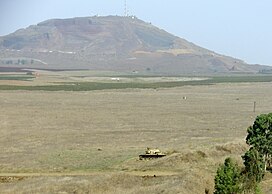
Mount Peres (Template:Lang-ar, Tall al-Faras, Template:Lang-he, Har Peres) is a volcanic mountain located in central Golan Heights, some 5.5 kilometres (3.4 mi) east of Moshav Keshet. Its highest point is 929 metres (3,048 ft) above sea level, or about 200 metres (660 ft) above ground level. The mountain is the southernmost of a series of dormant volcanoes that stretch up to the northern parts of the Golan Heights. On top of the mountain is a well-preserved crater, 200 meters in diameter and 35 metres (115 ft) deep.
References
This geography of Israel article is a stub. You can help Misplaced Pages by expanding it. |