This is an old revision of this page, as edited by Veillg1 (talk | contribs) at 13:31, 21 January 2020 (→Toponymy: Add reference to Commission de toponymie du Québec.). The present address (URL) is a permanent link to this revision, which may differ significantly from the current revision.
Revision as of 13:31, 21 January 2020 by Veillg1 (talk | contribs) (→Toponymy: Add reference to Commission de toponymie du Québec.)(diff) ← Previous revision | Latest revision (diff) | Newer revision → (diff) This article is about river which joins the St. Lawrence at Beaupré. For river which joins the St. Lawrence at Ste-Anne-de-la-Pérade, see Sainte-Anne River. River in Quebec, Canada| Sainte-Anne River Rivière Sainte-Anne-du-Nord | |
|---|---|
 Sainte-Anne (Beaupré) River Sainte-Anne (Beaupré) River | |
| Location | |
| Country | Canada |
| Province | Quebec |
| Region | Capitale-Nationale |
| Regional County Municipality | La Côte-de-Beaupré Regional County Municipality |
| Physical characteristics | |
| Source | Lac Sainte-Anne-du-Nord |
| • location | Lac-Pikauba |
| • coordinates | 47°41′08″N 70°44′11″W / 47.685499°N 70.736332°W / 47.685499; -70.736332 |
| • elevation | 914 m (2,999 ft) |
| Mouth | Saint Lawrence River |
| • location | Beaupré, MRC La Côte-de-Beaupré Regional County Municipality |
| • coordinates | 47°02′24″N 70°53′00″W / 47.040051°N 70.883446°W / 47.040051; -70.883446 |
| • elevation | 6 m (20 ft) |
| Length | 97 km (60 mi) |
| Basin size | 1,077 km (416 sq mi) |

Ste-Anne-du-Nord River is a river in Capitale-Nationale, Quebec, Canada. The river passes through Canyon Sainte-Anne before joining the Saint Lawrence River at Beaupré.
Geography
Rivière Sainte-Anne is a river in the Capitale-Nationale region. It has a length of 97 km, covers a basin of
Natural number| Expression error: Unrecognized word "sainte". | |
|---|---|
| Expression error: Unrecognized word "sainte". Expression error: Unrecognized word "sainte". | |
| Cardinal | Lua error in Module:ConvertNumeric at line 576: Invalid decimal numeral. |
| Ordinal | Sainte-Anne Riverth (Lua error in Module:ConvertNumeric at line 576: Invalid decimal numeral.) |
| Factorization | Expression error: Unrecognized word "sainte". |
| Greek numeral | Expression error: Unrecognized word "sainte". |
| Roman numeral | Expression error: Unrecognized word "sainte". |
| Binary | Expression error: Unrecognized word "sainte". |
| Ternary | Expression error: Unrecognized word "sainte". |
| Senary | Expression error: Unrecognized word "sainte". |
| Octal | Expression error: Unrecognized word "sainte". |
| Duodecimal | Expression error: Unrecognized word "sainte". |
| Hexadecimal | Expression error: Unrecognized word "sainte". |
and has an average flow of 26 m3/s. The river finds its source at Lac Sainte-Anne-du-Nord. From there, it flows south and ends at Beaupré, opposite Île d'Orléans, 35 km northeast of the city of Quebec in the St. Lawrence River.
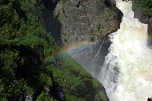
In Saint-Ferréol-les-Neiges are the Seven Chutes, falls which in many cases are 128 m high. Then the river crosses the Canyon Sainte-Anne, a gorge with a length of 10 km. At its end, in Saint-Joachim is the Sainte-Anne waterfall, 74 m high.
Toponymy
The toponym "Rivière Sainte-Anne" was formalized on April 4, 1982 at the Place Names Bank of the Commission de toponymie du Québec
Sept-Chutes hydroelectric plant
The Sept-Chutes power plant, a hydroelectric power plant run-of-the-water power plant belonging to Hydro-Québec is on the Sainte-Anne river. It was built in 1916 and modernized in 1999. It has 4 turbines for a total output of 22 MW. The hydraulic potential amounts to 124.97 m. The power station can be visited.
 |
Hydro-Canyon hydroelectric plant
It was in 2016 that the hydroelectric power station of Société Hydro-Canyon Saint-Joachim started up a hydroelectric power station over water 300 meters upstream from Canyon Sainte-Anne.
The Hydro-Canyon Saint-Joachim run-of-river power plant project was designed taking into account the technical and environmental aspects of the integration environment.
The development will harmonize with the recreotourism facilities of Canyon Sainte-Anne.
The works will optimize the site on the hydroelectric level while developing the potential of the Sainte-Anne waterfall. The maximum power of the plant will be 23.2 MW.
The installation will include:
- A weir threshold to maintain the upstream level of the river
- A spillway
- A water intake
- An entrance gallery
- A power plant including production equipment
- A substation and a power line connecting the site to the Hydro-Québec network
Sport

The Sainte-Anne-du-Nord river has also been used since 1966 by a club and a river kayak school. First bearing the name of Club Echohamok, it has evolved to bear today the name of Côte-de-Beaupré. It must be said that the Sainte-Anne-du-Nord river has a portion of river located between the Sept-Chutes hydroelectric plant and the Hydro-Canyon hydroelectric plant which is classified 5 stars by the guide of rivers of Quebec.
Notes and references
- Sainte-Anne-du-Nord River Committee
- Sept Chutes
- - Commission de toponymie du Québec - Rivière Sainte-Anne.
- Hydro-Québec: Hydroelectric power stations
Appendices
Map all coordinates using OpenStreetMapDownload coordinates as:
Related articles
This article related to a river in Quebec, Canada is a stub. You can help Misplaced Pages by expanding it. |