 | |
| Maintained by | DDOT |
|---|---|
| Length | 6.4 mi (10.3 km) |
| Location | Northwest, Washington, D.C. |
| South end | H Street at Lafayette Park |
| Major junctions | |
| North end | Georgia Ave in Silver Spring |
| East | 15th Street |
| West | 17th Street |
| Construction | |
| Commissioned | 1791 |
16th Street Northwest, briefly known as the Avenue of the Presidents, is a prominent north-south boulevard in Washington, D.C., located in Northwest D.C. The street was laid out as part of the 1791 L'Enfant Plan, which served as the original blueprint for the city. The street begins just north of the White House, across from Lafayette Square in the President's Park, and continues north along the Washington meridian until Blair Circle.
The street passes through several notable landmarks and thoroughfares, including K Street, Scott Circle, Meridian Hill Park, Rock Creek Park before crossing Eastern Avenue into Silver Spring, Maryland, where it ends at Georgia Avenue. From K Street to the District line, it is part of the National Highway System, while the Maryland portion is designated Maryland Route 390. The entire street is 6.4 miles (10.3 km) long. Part of the street is listed on the National Register of Historic Places as Sixteenth Street Historic District. In June 2020, the section immediately north of the White House was renamed Black Lives Matter Plaza.
History

16th Street was developed by Pierre Charles L'Enfant as part of the 1791 L'Enfant Plan, the foundational urban plan of Washington.
World War I Memorial Trees
In 1920, more than 500 trees were planted along 16th Street between Alaska Avenue and Varnum Street to honor fallen soldiers from World War I. Today, the 16th Street World War I Memorial Trees and their corresponding markers have largely been lost to history.
Ronald Reagan Boulevard 2005 proposal

In July 2005, just before Congress's summer recess, Texas Republican congressman Henry Bonilla quietly introduced resolution H.R. 3525 to rename 16th Street NW "Ronald Reagan Boulevard" in honor of the former president of the United States. Mayor Anthony A. Williams objected on the grounds that the proposal would have changed Pierre L'Enfant's 1791 design for the city and cost an estimated $1 million for new signs and maps. The plan was ultimately quashed by Rep. Tom Davis, chairman of the House Government Reform Committee and a fellow Republican representing Washington's Virginia suburbs.
Black Lives Matter Plaza renaming
Main article: Black Lives Matter Plaza
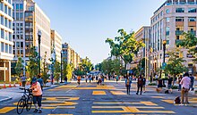
On June 5, 2020, during the George Floyd protests in Washington, D.C., the city's Department of Public Works painted the words "Black Lives Matter" in 35-foot yellow capital letters on 16th Street NW near the White House and Lafayette Square, with the help of the department's MuralsDC program. The D.C. flag accompanied the text. Later that day, Mayor Muriel Bowser announced that part of the street had been ceremonially renamed Black Lives Matter Plaza.
On June 6, 2020, activists altered the mural. They removed the stars from the D.C. flag, changing it to an equals sign, and added the words "defund the police" so that the mural read "Black Lives Matter = Defund the Police".
Significance
Main article: Sixteenth Street Historic District
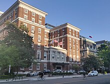
Early in the city's history, many foreign countries opened their embassies on 16th Street because of its proximity to the White House. Many religious denominations followed with churches, earning the street the nickname "Church Row." These include Foundry Methodist (attended by Presidents Hayes and Clinton), First Baptist (attended by Presidents Truman and Carter), the Nineteenth Street Baptist Church which was originally named the First Colored Baptist Church of Washington, D.C. (visited twice by President Barack Obama), St. John's ("Church of the Presidents"), All Souls Unitarian, Universalist National Memorial Church, St. John the Baptist Russian Orthodox Cathedral, founded in 1949 and built in 1958, and Third Church of Christ, Scientist, which was designed by an associate of I.M. Pei in 1971 and demolished in 2014. Shrine of the Sacred Heart is located just off of 16th Street. After most of the embassies moved to Embassy Row and other parts of the city, the churches became more prominent in 16th Street's identity. Other notable buildings include the Scottish Rite Masons' House of the Temple, Carnegie Institution for Science, Robert Simpson Woodward House, the Warder Mansion, Carter Barron Amphitheater, the Washington, D.C. Jewish Community Center, and the Toutorsky Mansion.

The AFL–CIO, American Trucking Association, National Education Association, American Chemical Society, National Geographic Society, and Benjamin Franklin University have prominent buildings on 16th Street. The National Rifle Association of America was headquartered on the street until the late 1990s.
By the end of the 19th century, 16th Street NW stretched some 2.5 miles from the White House north to Morris Road NW (now Monroe Street NW). On March 30, 1899, the United States Congress authorized the extension of the street to the D.C.-Maryland line. Within two years, the city completed condemnation proceedings to obtain the necessary land. But bridging the natural obstacle of the Piney Branch valley—with the nation's first parabolic arch bridge—would take until 1909.

The northern and central portions of 16th Street—and the Crestwood neighborhood, in particular—have for a half century been the chosen neighborhood of accomplished African Americans in Washington. Known colloquially as "The Gold Coast", these sections of 16th Street are lined with early 20th-century Tudor mansions. As 16th Street continues north through the Shepherd Park neighborhood, the street passes 7700 16th Street NW, a Tudor-style house that was the scene of a notorious crime; several houses of worship, including the Ohev Sholom synagogue and historic Tiffereth Israel synagogue, across the street from one another; and the Washington Ethical Society.
The street's proximity to Rock Creek Park and importance as a thoroughfare has made it a natural dividing boundary for Washington neighborhoods. Outside of the downtown area, no neighborhood in the city falls on both sides of 16th Street; the neighborhoods that surround it have 16th as either their eastern or their western boundary. For many years, the wide street was the de facto "boundary" between Caucasian and African-American neighborhoods of the city, especially in the tense years after the 1968 race riots.
A pair of similarly named streets, 16th Street Northeast and 16th Street Southeast, are three miles (5 km) away in the northeast and southeast quadrants of Washington. They are contiguous with each other and parallel to 16th Street NW. There is no 16th Street Southwest, as this space is occupied by the National Mall and the Washington Channel.
References
- ^ "16th Street NW" (Map). Google Maps. Retrieved March 3, 2019.
- ^ Conroy, Sarah Booth (March 18, 1979). "16th Street—The Avenue of Aspirations; A Street Of Dreams". The Washington Post. pp. C01.
- "Greater Greater Washington - Lost Washington: Mary Foote Henderson's Boundary Castle". Archived from the original on July 7, 2023. Retrieved July 6, 2023.
- Anne H. Helwig and Suzanne Ganschiuietz (January 30, 1978). "National Register of Historic Places Inventory/Nomination: Sixteenth Street Historic District". Archived from the original on June 7, 2020. Retrieved March 9, 2016. and accompanying 17 photos
- Nirappil, Fenit; Zauzmer, Julie; Chason, Rachel. "'Black Lives Matter': In giant yellow letters, D.C. mayor sends message to Trump". The Washington Post. Archived from the original on June 17, 2020. Retrieved June 6, 2020.
- "White House Historical Association". Archived from the original on July 17, 2015. Retrieved July 6, 2023.
- http://thomas.loc.gov/cgi-bin/bdquery/z?d109:h.r.03525:
- Hsu, Spencer (August 5, 2005). "A Roadblock for Reagan". The Washington Post. Archived from the original on November 13, 2016. Retrieved August 22, 2017.
- Austermuhle, Mark; Cheslow, Daniella (June 5, 2020). "D.C. Renames Intersection Near White House 'Black Lives Matter Plaza,' Paints 35-Foot Message On Street". DCist. Archived from the original on June 5, 2020. Retrieved June 5, 2020.
- Barnes, Sophie; Finch, Justin (June 5, 2020). "City of DC Painting 'Black Lives Matter' on Street Near White House". NBC Washington. Archived from the original on June 5, 2020. Retrieved June 5, 2020.
- Willingham, AJ (June 5, 2020). "Washington DC paints a giant 'Black Lives Matter' message on the road to the White House". CNN. Archived from the original on June 5, 2020. Retrieved June 5, 2020.
- "City of DC Names Street to White House After Black Lives Matter; Emblazons Name on Road". NBC Washington. Archived from the original on June 5, 2020. Retrieved June 5, 2020.
- Wu, Nicholas. "DC renames street near White House 'Black Lives Matter Plaza' to honor George Floyd protests". USA Today. Archived from the original on June 5, 2020. Retrieved June 5, 2020.
- "Black Lives Matter Adds 'Defund the Police' to Downtown Mural". MidCity DC News. June 7, 2020. Archived from the original on June 9, 2020. Retrieved June 7, 2020.
- Samantha Schmidt; Jessica Contrera; Rebecca Tan; Hannah Natanson; John Woodrow Cox (June 7, 2020). "'Defund The Police' painted on D.C. street as tensions among protesters flare". The Washington Post. Retrieved June 7, 2020.
- Michael D. Shear (March 18, 1993). "NRA makes move to Fair Oaks". The Washington Post. Archived from the original on February 11, 2021. Retrieved May 17, 2023.
The National Rifle Association has decided to move 400 of its employees from the District to a new building in the Fair Oaks section of Fairfax County, Board of Supervisors Chairman Thomas M. Davis III said.
- "His Annual Report". The Evening Star. November 11, 1902. p. 7.
- "Bridge Nearly Ready". The Washington Post. March 25, 1910. p. 16.
- Lewis, Neil A. (May 19, 1985). "The Shifting 'Gold Coast'". The New York Times. Archived from the original on July 27, 2018. Retrieved April 18, 2010.
| Streets and highways of Washington, D.C. | |
|---|---|
| Numbered streets | |
| Lettered streets | |
| State-named roadways | |
| Border avenues and streets |
|
| Other streets | |
| Circles | |
| Squares | |
| Parkways | |
| Expressways | |