| Coordinates
|
Country, territory or sea
|
Notes
|
| 38°0′N 0°0′E / 38.000°N 0.000°E / 38.000; 0.000 (Prime Meridian)
|
Mediterranean Sea
|
Passing just north of the island of Marettimo,  Italy (at 37°59′43″N 12°1′47″E / 37.99528°N 12.02972°E / 37.99528; 12.02972 (Marettimo)) Italy (at 37°59′43″N 12°1′47″E / 37.99528°N 12.02972°E / 37.99528; 12.02972 (Marettimo))
|
| 38°0′N 12°19′E / 38.000°N 12.317°E / 38.000; 12.317 (Italy)
|
 Italy Italy
|
Islands of Levanzo and Sicily
|
| 38°0′N 15°25′E / 38.000°N 15.417°E / 38.000; 15.417 (Mediterranean Sea)
|
Mediterranean Sea
|
Strait of Messina
|
| 38°0′N 15°38′E / 38.000°N 15.633°E / 38.000; 15.633 (Italy)
|
 Italy Italy
|
Passing through Reggio di Calabria (southern suburbs)
|
| 38°0′N 16°8′E / 38.000°N 16.133°E / 38.000; 16.133 (Mediterranean Sea)
|
Mediterranean Sea
|
Ionian Sea - passing between the islands of Kefalonia (at 38°4′N 20°43′E / 38.067°N 20.717°E / 38.067; 20.717 (Kefalonia)) and Zakynthos (at 37°56′N 20°42′E / 37.933°N 20.700°E / 37.933; 20.700 (Zakynthos)),  Greece Greece
|
| 38°0′N 21°16′E / 38.000°N 21.267°E / 38.000; 21.267 (Greece)
|
 Greece Greece
|
Passing through Athens
|
| 38°0′N 24°2′E / 38.000°N 24.033°E / 38.000; 24.033 (Aegean Sea)
|
Aegean Sea
|
|
| 38°0′N 24°14′E / 38.000°N 24.233°E / 38.000; 24.233 (Greece)
|
 Greece Greece
|
Islands of Petalioi and Euboea
|
| 38°0′N 24°34′E / 38.000°N 24.567°E / 38.000; 24.567 (Aegean Sea)
|
Aegean Sea
|
Passing just north of the island of Andros (at 37°59′57″N 24°47′23″E / 37.99917°N 24.78972°E / 37.99917; 24.78972 (Andros)),  Greece Greece
|
| 38°0′N 27°7′E / 38.000°N 27.117°E / 38.000; 27.117 (Turkey)
|
 Turkey Turkey
|
Passing through Konya, Niğde and İzmir (southern suburbs)
|
| 38°0′N 44°17′E / 38.000°N 44.283°E / 38.000; 44.283 (Iran)
|
 Iran Iran
|
Passing just south of Tabriz
|
| 38°0′N 48°55′E / 38.000°N 48.917°E / 38.000; 48.917 (Caspian Sea)
|
Caspian Sea
|
|
| 38°0′N 53°49′E / 38.000°N 53.817°E / 38.000; 53.817 (Turkmenistan)
|
 Turkmenistan Turkmenistan
|
|
| 38°0′N 55°17′E / 38.000°N 55.283°E / 38.000; 55.283 (Iran)
|
 Iran Iran
|
|
| 38°0′N 57°22′E / 38.000°N 57.367°E / 38.000; 57.367 (Turkmenistan)
|
 Turkmenistan Turkmenistan
|
Passing just north of Ashgabat
|
| 38°0′N 66°38′E / 38.000°N 66.633°E / 38.000; 66.633 (Uzbekistan)
|
 Uzbekistan Uzbekistan
|
|
| 38°0′N 68°17′E / 38.000°N 68.283°E / 38.000; 68.283 (Tajikistan)
|
 Tajikistan Tajikistan
|
|
| 38°0′N 70°19′E / 38.000°N 70.317°E / 38.000; 70.317 (Afghanistan)
|
 Afghanistan Afghanistan
|
|
| 38°0′N 71°16′E / 38.000°N 71.267°E / 38.000; 71.267 (Tajikistan)
|
 Tajikistan Tajikistan
|
|
| 38°0′N 74°54′E / 38.000°N 74.900°E / 38.000; 74.900 (China)
|
 People's Republic of China People's Republic of China
|
Xinjiang
Qinghai
Gansu
Inner Mongolia
Ningxia
Inner Mongolia
Shaanxi − for around 5 km (3.1 mi)
Inner Mongolia − for around 14 km (8.7 mi)
Shaanxi
Shanxi — passing just north of Taiyuan
Hebei — passing just south of Shijiazhuang
Shandong
|
| 38°0′N 118°58′E / 38.000°N 118.967°E / 38.000; 118.967 (Yellow Sea)
|
Yellow Sea
|
Passing just north of Baengnyeong Island (at 37°59′N 124°41′E / 37.983°N 124.683°E / 37.983; 124.683 (Baengnyeong)),  South Korea South Korea
|
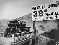
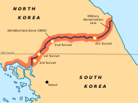
| 38°0′N 125°7′E / 38.000°N 125.117°E / 38.000; 125.117 (North Korea)
|
 North Korea North Korea
|
Ongjin Peninsula — South Hwanghae Province
|
| 38°0′N 125°35′E / 38.000°N 125.583°E / 38.000; 125.583 (Yellow Sea)
|
Yellow Sea
|
Ongjin Bay
|
| 38°0′N 125°46′E / 38.000°N 125.767°E / 38.000; 125.767 (North Korea)
|
 North Korea North Korea
|
South Hwanghae Province
passing just south of Haeju
North Hwanghae Province
passing just north of Kaesong
|
| 38°0′N 126°49′E / 38.000°N 126.817°E / 38.000; 126.817 (South Korea)
|
 South Korea South Korea
|
Gyeonggi Province- Passing through Paju, Yeoncheon County, Pocheon, Gapyeong County
Gangwon Province - Passing through Hwacheon County, Chuncheon, (passing just north of Soyang Reservoir), Inje County, Yangyang County
|
| 38°0′N 128°44′E / 38.000°N 128.733°E / 38.000; 128.733 (Sea of Japan)
|
Sea of Japan
|
|
| 38°0′N 138°14′E / 38.000°N 138.233°E / 38.000; 138.233 (Japan)
|
 Japan Japan
|
Island of Sado:
— Niigata Prefecture
|
| 38°0′N 138°33′E / 38.000°N 138.550°E / 38.000; 138.550 (Sea of Japan)
|
Sea of Japan
|
|
| 38°0′N 139°14′E / 38.000°N 139.233°E / 38.000; 139.233 (Japan)
|
 Japan Japan
|
Island of Honshū:
— Niigata Prefecture
Passing just north of Niigata City
— Yamagata Prefecture
— Miyagi Prefecture
|
| 38°0′N 140°55′E / 38.000°N 140.917°E / 38.000; 140.917 (Pacific Ocean)
|
Pacific Ocean
|
|
| 38°0′N 123°1′W / 38.000°N 123.017°W / 38.000; -123.017 (United States)
|
 United States United States
|
California - passing through Pinole and Stockton With Sacramento a little to the north
Nevada - passing just south of Tonopah
Utah - passing through Capitol Reef and Canyonlands National Parks
Colorado - passing through Ouray, and then just south of Pueblo
Kansas - passing just south of Newton
Missouri - passing through Camdenton and just north of Rolla
Illinois - passing just south of Mount Vernon
Indiana - passing through Evansville
Kentucky - passing through Lexington
West Virginia - passing just north of Beckley
Virginia - passing just south of Charlottesville
|
| 38°0′N 76°28′W / 38.000°N 76.467°W / 38.000; -76.467 (Chesapeake Bay)
|
Chesapeake Bay
|
|
| 38°0′N 75°53′W / 38.000°N 75.883°W / 38.000; -75.883 (United States)
|
 United States United States
|
Maryland - passing just north of Smith Island and Crisfield
Virginia - passing just north of Chincoteague
|
| 38°0′N 75°16′W / 38.000°N 75.267°W / 38.000; -75.267 (Pacific Ocean)
|
Atlantic Ocean
|
Passing between Pico (at 38°23′N 28°14′W / 38.383°N 28.233°W / 38.383; -28.233 (Pico)) and São Miguel (at 37°55′N 25°47′W / 37.917°N 25.783°W / 37.917; -25.783 (São Miguel)) islands, Azores,  Portugal Portugal
|
| 38°0′N 8°51′W / 38.000°N 8.850°W / 38.000; -8.850 (Portugal)
|
 Portugal Portugal
|
Setúbal District
Beja District - passing just south of Beja
|
| 38°0′N 7°12′W / 38.000°N 7.200°W / 38.000; -7.200 (Spain)
|
 Spain Spain
|
Andalusia
Extremadura
Region of Murcia - passing just north of Murcia
Valencian Community
|
| 38°0′N 0°39′W / 38.000°N 0.650°W / 38.000; -0.650 (Mediterranean Sea)
|
Mediterranean Sea
|
|
 38°class=notpageimage| 38th parallel north


