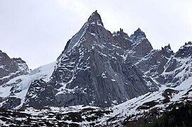
| Aiguille de Blaitière | |
|---|---|
 | |
| Highest point | |
| Elevation | 3,522 m (11,555 ft) |
| Coordinates | 45°53′57″N 06°54′47″E / 45.89917°N 6.91306°E / 45.89917; 6.91306 |
| Geography | |
 | |
| Location | Haute-Savoie, France |
| Parent range | Mont Blanc Massif |
| Climbing | |
| First ascent | 6 August 1874 by E.R. Whitwell with C. and J. Lauener |
The Aiguille de Blaitière (3,522 m) is a mountain in the Mont Blanc Massif in Haute-Savoie, France.
This Haute-Savoie geographical article is a stub. You can help Misplaced Pages by expanding it. |


