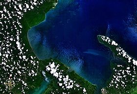
Amatique Bay is a large bay in the Gulf of Honduras, along the eastern coast of Guatemala and Belize. It stretches from Santo Tomás de Castilla in the south to Punta Gorda in the north, where it opens to the Caribbean Sea. Its south-eastern limits are marked by a small peninsula known as Punta de Manabique where a $27 million gas terminal is planned
Most of the bay is part of Guatemala, while the northwestern portion is part of Belize. The bay receives the runoff from three major rivers: the Moho River in Belize, the Sarstoon River forming the border between Belize and Guatemala, and Dulce River in Guatemala. The main ports in the bay are Puerto Barrios, Santo Tomás de Castilla and Livingston (Guatemala), and Punta Gorda (Belize).
References
- "Planned gas terminal". Archived from the original on 2011-09-28. Retrieved 2011-07-25.
- "Amatique Bay". Google Maps. Retrieved 19 January 2019.
External links
- Perez, Arlenie; Chuang Chin-Ta; Farok Afero (2009). "Belize-Guatemala territorial dispute and its implications for conservation" (PDF). Tropical Conservation Science. 2 (1): 11–24. doi:10.1177/194008290900200104. S2CID 55033773.
- Perlack, Robert D.; J. Timothy Ensminger; Romeo Martinez (2001). "Guatemala strives for environmental and economic sustainability in the Rio Dulce region". Natural Resources Forum. 25 (3): 235–244. doi:10.1111/j.1477-8947.2001.tb00765.x.
Sources
15°55′00″N 88°45′00″W / 15.91667°N 88.75000°W / 15.91667; -88.75000
This Guatemala location article is a stub. You can help Misplaced Pages by expanding it. |
This article about the geography of Belize is a stub. You can help Misplaced Pages by expanding it. |