| Warin Chamrap วารินชำราบ | |
|---|---|
| District | |
 Aerial view of Warin Chamrap on November 3, 2010 Aerial view of Warin Chamrap on November 3, 2010 | |
 District location in Ubon Ratchathani province District location in Ubon Ratchathani province | |
| Coordinates: 15°12′9″N 104°52′3″E / 15.20250°N 104.86750°E / 15.20250; 104.86750 | |
| Country | Thailand |
| Province | Ubon Ratchathani |
| Seat | Warin Chamrap |
| Area | |
| • Total | 691.0 km (266.8 sq mi) |
| Population | |
| • Total | 156,355 |
| • Density | 226.3/km (586/sq mi) |
| Time zone | UTC+7 (ICT) |
| Postal code | 34190 |
| Geocode | 3415 |
Warin Chamrap (Thai: วารินชำราบ, pronounced [wāː.rīn tɕʰām.râːp]; Northeastern Thai: วารินซำราบ, pronounced [wa᷇ː.li᷇n sa᷇m.lâːp]) is a district (amphoe) in the western part of Ubon Ratchathani province, northeastern Thailand (Isan).
Geography
Neighboring districts are (from the north clockwise) Mueang Ubon Ratchathani, Sawang Wirawong, Na Yia, Det Udom, Samrong of Ubon Ratchathani Province, and Kanthararom of Sisaket province.
The important water resource is the Mun River. Warin Chamrap is located just 2 kilometers (1 mi) from Mueang Ubon Ratchathani, with Mun River between them.
History
In 1913 the district was renamed from Thaksin Ubon (ทักษิณอุบล) to Warin Chamrap.

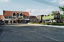
Since 1938, Warin Chamrap has been the eastern terminus of the northeastern railway line from Bangkok's central Hua Lamphong Railway Station via the Nakhon Ratchasima Railway Station.
Education

Ubon Ratchathani University is in Warin Chamrap District.
Administration
The district is divided into 16 sub-districts (tambons), which are further subdivided into 185 villages (mubans). The town (thesaban mueang) Warin Chamrap covers the tambon Warin Chamrap. There are two more townships (thesaban tambon): Saen Suk covers tambon Saen Suk, and Huai Kha Yung covers parts of tambon Huai Kha Yung. There are a further 15 tambon administrative organizations (TAO).
| No. | Name | Thai name | Villages | Pop. | |
|---|---|---|---|---|---|
| 1. | Warin Chamrap | วารินชำราบ | - | 30,725 | |
| 2. | That | ธาตุ | 10 | 5,372 | |
| 4. | Tha Lat | ท่าลาด | 12 | 6,940 | |
| 5. | Non Non | โนนโหนน | 12 | 6,435 | |
| 7. | Khu Mueang | คูเมือง | 12 | 7,436 | |
| 8. | Sa Saming | สระสมิง | 16 | 7,795 | |
| 10. | Kham Nam Saep | คำน้ำแซบ | 9 | 8,412 | |
| 11. | Bung Wai | บุ่งหวาย | 20 | 10,390 | |
| 15. | Kham Khwang | คำขวาง | 8 | 7,263 | |
| 16. | Pho Yai | โพธิ์ใหญ่ | 13 | 7,476 | |
| 18. | Saen Suk | แสนสุข | 20 | 22,375 | |
| 20. | Nong Kin Phen | หนองกินเพล | 9 | 6,704 | |
| 21. | Non Phueng | โนนผึ้ง | 10 | 6,653 | |
| 22. | Mueang Si Khai | เมืองศรีไค | 10 | 8,071 | |
| 24. | Huai Khayung | ห้วยขะยูง | 13 | 6,443 | |
| 26. | Bung Mai | บุ่งไหม | 11 | 7,865 |
Missing numbers are tambon which now form the districts Samrong and Sawang Wirawong.
References
- แจ้งความกระทรวงมหาดไทย เรื่อง เปลี่ยนนามอำเภอ (PDF). Royal Gazette (in Thai). 30 (ง): 1536–1537. October 12, 1913. Archived from the original (PDF) on January 25, 2012.
External links
| Districts of Ubon Ratchathani | |
|---|---|
This Ubon Ratchathani Province location article is a stub. You can help Misplaced Pages by expanding it. |