Human settlement in Scotland
Ardchronie
| |
|---|---|
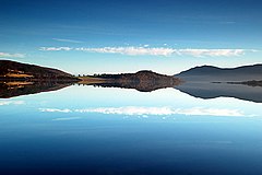
 Christmas Day 2008 Dornoch Firth Taken at Ardchronie. Christmas Day 2008 Dornoch Firth Taken at Ardchronie. | |
 | |
| OS grid reference | NH6188 |
| Council area | |
| Country | Scotland |
| Sovereign state | United Kingdom |
| Postcode district | IV24 3 |
| Police | Scotland |
| Fire | Scottish |
| Ambulance | Scottish |
| UK Parliament | |
| Scottish Parliament | |
| 57°51′59″N 4°20′06″W / 57.8665°N 4.3351°W / 57.8665; -4.3351 | |
Ardchronie (Scottish Gaelic: Àird Chrònaidh) is a hamlet in the Highland Council area of Scotland. It lies on the south side of the Dornoch Firth, about 2 miles south of Bonar Bridge. Upper Ardchronie is on the hill above Ardchronie.
References
- Microsoft; Nokia. "Ardchronie" (Map). Bing Maps. Microsoft. Retrieved 7 March 2017.
- "Ardchronie". The Gazetteer for Scotland. School of GeoSciences, University of Edinburgh and The Royal Scottish Geographical Society. Retrieved 4 January 2018.
This Highland location article is a stub. You can help Misplaced Pages by expanding it. |