| Bømlafjorden | |
|---|---|
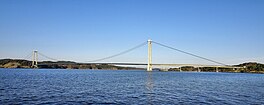
 View of the fjord and the Stord Bridge View of the fjord and the Stord Bridge | |
  | |
| Location | Vestland county, Norway |
| Coordinates | 59°38′N 5°17′E / 59.633°N 5.283°E / 59.633; 5.283 |
| Type | Fjord |
| Primary inflows | Hardangerfjorden |
| Basin countries | Norway |
| Max. length | 30 kilometres (19 mi) |
Bømlafjorden (English: Bømla Fjord) is a fjord in Vestland county, Norway. The fjord is the outer-most part of the Hardangerfjord, running between the island of Bømlo (in Bømlo Municipality) and the mainland (Sveio Municipality). The Bømlafjord Tunnel crosses under Bømlafjorden.
History
King Magnus IV of Sweden and Norway drowned in a shipwreck in the fjord in 1374.
On February 21, 1945, the vessel D/S Austri was attacked by British aircraft and sunk in the fjord. The passengers included German military personnel, prisoners of war, and civilian passengers, among them the judge and newspaperman Gerhard Jynge.
See also
References
- Norsk kulturarv: Ryvarden Lighthouse.
- Norwegian Coastal Administration: VTS Centres.
- Bulletin of the Geological Society of Denmark 41–42 (1994), pp. 7–8.
- Mjånes, Willy Edvin. 2010. Sjøverts kommunikasjon på Haugalandet. Årbok for Haugalandmuseene, pp. 14–51. Haugesund: Haugalandmuseene, pp. 41-42, 45.
- DigitaltMuseum: Det gamle skatollet.
- Olderkjær, Ove A. 2015. Kystruta skoten i senk av sine eigne. Bergens Tidene (February 20).
This Vestland location article is a stub. You can help Misplaced Pages by expanding it. |
This article about a fjord in Norway is a stub. You can help Misplaced Pages by expanding it. |