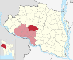
| Bagmara Upazila বাগমারা উপজেলা | |
|---|---|
| Upazila of Bangladesh | |
 Kompo River in Bagmara Kompo River in Bagmara | |
 | |
| Coordinates: 24°33.8′N 88°48.5′E / 24.5633°N 88.8083°E / 24.5633; 88.8083 | |
| Country | |
| Division | Rajshahi |
| District | Rajshahi |
| Area | |
| • Total | 366.26 km (141.41 sq mi) |
| Population | |
| • Total | 373,945 |
| • Density | 1,000/km (2,600/sq mi) |
| Time zone | UTC+6 (dhaka) |
| Postal code | 6250 |
| Website | bagmara |
Bagmara Upazila (Bengali: বাগমারা উপজেলা) is an upazila of Rajshahi District in the Division of Rajshahi, Bangladesh.
Geography
Bagmara is located to the north of Rajshahi city, about 42km distant from the city. It is located within 24°30' and 24°41' north latitudes and 88°41' and 88°58' east longitudes. To the north of Bagmara are Atrai and Manda upazilas of Naogaon district; to the south are Durgapur and Puthia upazilas of Rajshahi; to the east are Sadar upazila of Natore and Atrai upazila; to the west are Mohanpur upazila of Rajshahi and Manda upazila. Total area of upazila is 366.26km.
According to NRCC catologue of rivers, Fakirni and Barnoi rivers flow through Bagmara.
History
Bagmara Thana was created in 1869 and was elevated to upazila in 1984.
During the 1971 War of Liberation, Pakistan Army engaged in surreptitious attack on Taherpur hat, causing death to 25 persons. The freedom fighters, led by Havilder Shafiq, mounted an attack on a Pakistani Army patrol boat, killing 18 Pakistani soldiers.
Demographics
| Religions in Baghmara Upazila (2022) | ||||
|---|---|---|---|---|
| Religion | Percent | |||
| Islam | 95.54% | |||
| Hinduism | 4.44% | |||
| Other or not stated | 0.02% | |||
According to the 2022 Bangladesh census, Bagmara upazila had 106,347 households, which is the highest among nine upazilas of Rajshahi. The population numbered at 373,945, the second highest among the upazilas of the district. The literacy rate stood at 69.21% among the whole population.
According to the 2011 Census of Bangladesh, Bagmara Upazila had 94,050 households and a population of 354,664. 64,230 (18.11%) were under 10 years of age. Bagmara had a literacy rate (age 7 and over) of 46.31%, compared to the national average of 51.8%, and a sex ratio of 1002 females per 1000 males. 38,214 (10.77%) lived in urban areas.
Administration
Bagmara is the sole upazila that comprises Rajshahi-4 parliamentary constituency. Prior to 2008 delimitation, Bagmara, with bordering Mohanpur upazila, formed the Rajshahi-3 constituency.
Bagmara Upazila is divided into 2 municipalities: Bhawanigonj and Taherpur; and 16 union parishads: Auchpara, Basupara, Borobihanoli, Dippur, Ganipur, Gobindapara, Gualkandi, Hamirkutsa, Jogipara, Kacharikoalipara, Maria, Nordas, Sonadanaga, Sreepur, Suvodanga, and Zhikra. The union parishads are further subdivided into 293 mauzas and 372 villages.
Notable residents
- Abdus Sattar Mondal was Member of Parliament twice for constituencies encompassing Bagmara Upazila.
- Sardar Amjad Hossain was elected MP in 1973, 1986 and 1988; served as Minister of Agriculture, Food, Land, Fisheries and Livestock at different times during H.M. Ershad's presidency.
- Abu Hena was a BNP politician and elected MP twice in 1996 and 2001.
- Enamul Haque was an Awami League politician and was elected MP in 2008, 2014, and 2018.
See also
References
- National Report (PDF). Population and Housing Census 2022. Vol. 1. Dhaka: Bangladesh Bureau of Statistics. November 2023. p. 402. ISBN 978-9844752016.
- Population and Housing Census 2022:District Report:Rajshahi (PDF). Bangladesh Bureau of Statistics. June 2024. p. 43. ISBN 978-984-475-230-6.
- "Bangladesh Postal Code". Dhaka: Bangladesh Postal Department under the Department of Posts and Telecommunications of the Ministry of Posts, Telecommunications and Information Technology of the People's Republic of Bangladesh. 21 October 2024.
- ^ Md Asadul Islam (2012), "Baghmara Upazila", in Sirajul Islam and Ahmed A. Jamal (ed.), Banglapedia: National Encyclopedia of Bangladesh (Second ed.), Asiatic Society of Bangladesh
- "ভৌগলিক অবস্থা" [Geograhical location]. bagmara.rajshahi.gov.bd. Retrieved 2024-09-01.
- ^ "Bangladesh Population and Housing Census 2011 Zila Report – Rajshahi" (PDF). bbs.gov.bd. Bangladesh Bureau of Statistics. p. 25.
- বাংলাদেশের নদ-নদী : সংজ্ঞা ও সংখ্যা [Rivers of Bangladesh: Definition and Numbers] (PDF) (in Bengali). National River Conservation Commission. 2023. pp. 48, 52.
- Population and Housing Census 2022 - District Report: Rajshahi (PDF). District Series. Dhaka: Bangladesh Bureau of Statistics. June 2024. ISBN 978-984-475-230-6.
- Population and Housing Census 2022 (PDF). Bangladesh Bureau of Statistics. 2023. p. 402. ISBN 978-984-475-201-6.
- "Community Tables: Rajshahi district" (PDF). bbs.gov.bd. Bangladesh Bureau of Statistics. 2011.
- Ali, Anwar; Rajshahi (2008-11-17). "AL hopeful of bagging most JS seats in Rajshahi". The Daily Star. Retrieved 2024-09-01.
- "Bagmara Upazila Statistics At-a-glance" (PDF). Retrieved 2024-09-01.
| Rajshahi District | ||
|---|---|---|
| Upazilas/thanas | ||
| Headquarters: Rajshahi | ||
| Bogra District |  | |
| Joypurhat District | ||
| Naogaon District | ||
| Natore District | ||
| Nawabganj District | ||
| Pabna District | ||
| Rajshahi District | ||
| Sirajganj District | ||
This Rajshahi Division location article is a stub. You can help Misplaced Pages by expanding it. |