Human settlement in England
| Barras | |
|---|---|
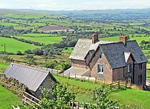
 Barn at Barras Farm Barn at Barras Farm | |
  | |
| OS grid reference | NY843120 |
| Civil parish | |
| Unitary authority | |
| Ceremonial county | |
| Region | |
| Country | England |
| Sovereign state | United Kingdom |
| Post town | Kirkby Stephen |
| Postcode district | CA17 |
| Dialling code | 01768 |
| Police | Cumbria |
| Fire | Cumbria |
| Ambulance | North West |
| UK Parliament | |
| 54°30′14″N 2°14′38″W / 54.504°N 2.244°W / 54.504; -2.244 | |
Barras is a hamlet close to the River Belah, about 4 miles (6 kilometres) south-east of Brough, Cumbria, England.

Until the creation of the new county of Cumbria, Barras was situated at the eastern edge of the historic county of Westmorland.
The hamlet is located at approximately 1,100 feet (340 metres) above sea level.
From 1861 until 1962 it was served by Barras railway station on the Stainmore railway line between Kirkby Stephen and Barnard Castle.
References
- Ordnance Survey: Landranger map sheet 91 Appleby-in-Westmorland (Brough & Kirkby Stephen) (Map). Ordnance Survey. 2014. ISBN 9780319231302.
- "Ordnance Survey: 1:50,000 Scale Gazetteer" (csv (download)). www.ordnancesurvey.co.uk. Ordnance Survey. 1 January 2016. Retrieved 30 January 2016.
This Cumbria location article is a stub. You can help Misplaced Pages by expanding it. |