| This article includes a list of references, related reading, or external links, but its sources remain unclear because it lacks inline citations. Please help improve this article by introducing more precise citations. (August 2017) (Learn how and when to remove this message) |
| Baumkirchen | |
|---|---|
| Municipality | |
 | |
 Coat of arms Coat of arms | |
 Location in the district Location in the district | |
 | |
| Coordinates: 47°17′59″N 11°33′00″E / 47.29972°N 11.55000°E / 47.29972; 11.55000 | |
| Country | Austria |
| State | Tyrol |
| District | Innsbruck Land |
| Government | |
| • Mayor | Josef Schindl (ÖVP) |
| Area | |
| • Total | 4.03 km (1.56 sq mi) |
| Elevation | 593 m (1,946 ft) |
| Population | |
| • Total | 1,284 |
| • Density | 320/km (830/sq mi) |
| Time zone | UTC+1 (CET) |
| • Summer (DST) | UTC+2 (CEST) |
| Postal code | 6121 |
| Area code | 05224 |
| Vehicle registration | IL |
| Website | www.baumkirchen.tirol.gv.at |
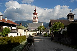
Baumkirchen is a community in the district of Innsbruck Land. It lies in the Inn Valley north of the Inn River on a batter of the Gnadenwald terrace. The village can be reached via the Inn Valley Motorway.
Population
| Year | Pop. | ±% |
|---|---|---|
| 1869 | 232 | — |
| 1880 | 260 | +12.1% |
| 1890 | 246 | −5.4% |
| 1900 | 256 | +4.1% |
| 1910 | 269 | +5.1% |
| 1923 | 292 | +8.6% |
| 1934 | 431 | +47.6% |
| 1939 | 416 | −3.5% |
| 1951 | 512 | +23.1% |
| 1961 | 543 | +6.1% |
| 1971 | 713 | +31.3% |
| 1981 | 870 | +22.0% |
| 1991 | 935 | +7.5% |
| 2001 | 1,085 | +16.0% |
| 2011 | 1,144 | +5.4% |
| 2015 | 1,217 | +6.4% |
References
- "Dauersiedlungsraum der Gemeinden Politischen Bezirke und Bundesländer - Gebietsstand 1.1.2018". Statistics Austria. Retrieved 10 March 2019.
- "Einwohnerzahl 1.1.2018 nach Gemeinden mit Status, Gebietsstand 1.1.2018". Statistics Austria. Retrieved 9 March 2019.
External links
- Town History (German)
- Municipality Baumkirchen: Official website of the municipality in the Hall-Wattens region