| Belaya | |
|---|---|
 | |
  | |
| Physical characteristics | |
| Mouth | Kuban |
| • coordinates | 45°06′00″N 39°28′09″E / 45.10000°N 39.46917°E / 45.10000; 39.46917 |
| Length | 265 km (165 mi) |
| Basin size | 5,990 km (2,310 sq mi) |
| Basin features | |
| Progression | Kuban→ Sea of Azov |
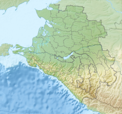
The Belaya (Russian: Бе́лая; Adyghe: Шъхьагуащэ, romanized: Ŝhagwaśæ [ʂħaːɡʷaːɕa]) is a river in the Republic of Adygea and Krasnodar Krai of Russia. It is a left tributary of the Kuban, which it joins in the Krasnodar Reservoir. The river is 265 kilometres (165 mi) long, with a drainage basin of 5,990 square kilometres (2,310 sq mi). It has its sources at the main watershed of the Caucasus Mountains. In its upper reaches it is a typical mountain river, and flows through deep canyons, while in its lower parts it is a slow flowing lowland river.
Its main tributaries are, from source to mouth, Kisha (right), Dakh (right), Kurdzhips (left) and Pshekha (left). Several cities and towns are located along the river including Maykop and Belorechensk.
References
- ^ "Река Белая in the State Water Register of Russia". textual.ru (in Russian).
External links
 Media related to Belaya River (Kuban) at Wikimedia Commons
This Krasnodar Krai location article is a stub. You can help Misplaced Pages by expanding it. |
This article related to a river in Southern Russia is a stub. You can help Misplaced Pages by expanding it. |