| Beuvron | |
|---|---|
 | |
 | |
  | |
| Location | |
| Country | France |
| Physical characteristics | |
| Source | |
| • location | Sologne |
| • elevation | 160 m (520 ft) |
| Mouth | near Candé-sur-Beuvron |
| • coordinates | 47°29′38″N 1°14′25″E / 47.49394°N 1.24014°E / 47.49394; 1.24014 |
| Length | 115 km (71 mi) |
| Basin size | 1,440 km (560 sq mi) |
| Basin features | |
| Progression | Loire→ Atlantic Ocean |
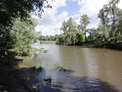
The Beuvron (French pronunciation: [bøvʁɔ̃] ; Latin: Bebronus) is a 115 km (71 mi) long river in Centre-Val de Loire, France, a left tributary of the river Loire. Its source is near the village of Coullons, southwest of Gien. The Beuvron flows generally west through the following departments and towns:
The Beuvron flows into the Loire at Candé-sur-Beuvron, near Chaumont-sur-Loire.
Tributaries
- Néant (in Vernou-en-Sologne)
- Cosson (in Candé-sur-Beuvron)
References
This Centre-Val de Loire geographical article is a stub. You can help Misplaced Pages by expanding it. |
This article related to a river in France is a stub. You can help Misplaced Pages by expanding it. |