| Białaszewo | |
|---|---|
| Village | |
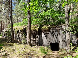
 World War II bunker in Białaszewo World War II bunker in Białaszewo | |
 | |
| Coordinates: 53°31′N 22°31′E / 53.517°N 22.517°E / 53.517; 22.517 | |
| Country | |
| Voivodeship | Podlaskie |
| County | Grajewo |
| Gmina | Grajewo |
| Time zone | UTC+1 (CET) |
| • Summer (DST) | UTC+2 (CEST) |
| Vehicle registration | BGR |
Białaszewo is a village in the administrative district of Gmina Grajewo, within Grajewo County, Podlaskie Voivodeship, in north-eastern Poland. It lies approximately 16 kilometres (10 mi) south of Grajewo and 62 km (39 mi) north-west of the regional capital Białystok.
History
Białaszewo was a private village of Polish nobility, administratively located in the Masovian Voivodeship in the Greater Poland Province of the Kingdom of Poland. In 1709, a church was erected by Seweryn Szczuka, suffragan bishop of Chełm.
Following the Third Partition of Poland (1795), Białaszewo was annexed by the Prussia. In 1807 it was regained by Poles, and included within the newly established, however short-lived Duchy of Warsaw. Following the duchy's dissolution in 1815, it fell to the Russian Partition of Poland. In 1827 Białaszewo had a population of 121. During the January Uprising, on March 31, 1863, it was the site of a battle between Polish insurgents and Russian troops, during which the Poles were able to retreat with only two casualties. In reprisal, the Russians carried out a massacre of the inhabitants. At least 16 people were killed, including women. After World War I, Poland regained independence and control of the village.
Sights
There are graves of the fallen insurgents of the January Uprising and the victims of the Russian-perpetrated massacre of 1863, and three World War II bunkers in Białaszewo.
References
- "Central Statistical Office (GUS) - TERYT (National Register of Territorial Land Apportionment Journal)" (in Polish). 2008-06-01.
- ^ Słownik geograficzny Królestwa Polskiego i innych krajów słowiańskich, Tom I (in Polish). Warszawa. 1880. p. 182.
{{cite book}}: CS1 maint: location missing publisher (link) - Zieliński, Stanisław (1913). Bitwy i potyczki 1863-1864. Na podstawie materyałów drukowanych i rękopiśmiennych Muzeum Narodowego w Rapperswilu (in Polish). Rapperswil: Fundusz Wydawniczy Muzeum Narodowego w Rapperswilu. p. 256.
- Katalog miejsc pamięci powstania styczniowego w województwie podlaskim (in Polish). Białystok: Towarzystwo Opieki nad Zabytkami Oddział Białystok. 2013. p. 48.
- Katalog miejsc pamięci powstania styczniowego w województwie podlaskim. pp. 120–121.
