| Bohoniki | |
|---|---|
| Village | |
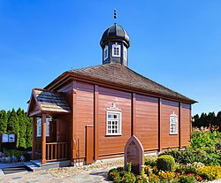
 Mosque in Bohoniki (2021) Mosque in Bohoniki (2021) | |
 | |
| Coordinates: 53°23′N 23°36′E / 53.383°N 23.600°E / 53.383; 23.600 | |
| Country | |
| Voivodeship | Podlaskie |
| County | Sokółka |
| Gmina | Sokółka |
| Population | |
| • Total | 100 |
| Time zone | UTC+1 (CET) |
| • Summer (DST) | UTC+2 (CEST) |
| Postal code | 16-100 |
| Vehicle registration | BSK |
Bohoniki (Polish Arabic: بوـحـونيكي) is a village in the administrative district of Gmina Sokółka, within Sokółka County, Podlaskie Voivodeship, in north-eastern Poland, close to the border with Belarus. It lies approximately 7 kilometres (4 mi) east of Sokółka and 42 km (26 mi) north-east of the regional capital Białystok.
Demographics
Bohoniki was primarily a Lipka Tatar settlement. According to the 1921 census, the village had a population of 208, of which 99.5% declared Polish nationality, 84.1% were Roman Catholic and 12.5% Muslim by confession. Today, still a few families in the village are Tatars and practicing Muslims. Although residents don't speak their native Tatar language (often written in Latin, Cyrillic or Arabic alphabet), they have close ties to Lipka Tatar and Islamic traditions.
Sights
Sites of interest in the village include a 19th-century wooden mosque and a Muslim cemetery, both named Historic Monuments of Poland (Pomnik historii), as designated November 20, 2012. Its listing is maintained by the National Heritage Board of Poland.
Gallery
-
 Mosque interior
-
 Cemetery entrance
-
 Muslim Lipka Tatar cemetery sign
-
 Cemetery
-
 Cemetery
-
 Monument commemorating the settlement of the Tatars in Bohoniki by King John III Sobieski
References
- "Oficjalny Spis Pocztowych Numerów Adresowych" (PDF). Poczta Polska (in Polish). Archived (PDF) from the original on 22 February 2014. Retrieved 9 January 2025.
- "Central Statistical Office (GUS) - TERYT (National Register of Territorial Land Apportionment Journal)" (in Polish). 2008-06-01.
- Skorowidz miejscowości Rzeczypospolitej Polskiej (in Polish). Vol. V. Warszawa: Główny Urząd Statystyczny. 1924. p. 77.
- Leonard Drożdżewicz (2016). "Biographical Dictionary of Polish Tatars of the Twentieth Century" (PDF). Znad Wilii. 4 (68): 77–82.
- Rozporządzenie Prezydenta Rzeczypospolitej Polskiej z dnia 22 października 2012 r. w sprawie uznania za pomnik historii "Bohoniki i Kruszyniany - meczety i mizary", Dz. U., 2012, No. 1275
This Sokółka County location article is a stub. You can help Misplaced Pages by expanding it. |
