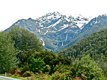
Waterfall in Queenstown-Lakes District, New Zealand
| Bridal Veil Falls (Otago-Route Burn) | |
|---|---|
 Bridal Veil as seen from the road to the Routeburn Track. Bridal Veil as seen from the road to the Routeburn Track. | |
| Location | Queenstown-Lakes District, New Zealand |
| Coordinates | 44°42′06″S 168°14′50″E / 44.70167°S 168.24722°E / -44.70167; 168.24722 |
| Type | Plunge |
| Total height | 57 metres (187 ft) |
The Bridal Veil Falls is a waterfall near Queenstown, Otago, in New Zealand. It is one of numerous streams and waterfalls in this region. This fall is only notable because it has been given a common name (Bridal Veil Falls), is clearly visible from the road and the stream from this fall runs under the third bridge of the Routeburn Track. This fall is over Torlesse Terrane metamorphic rock.
References
- Bridal Veil Bridge http://www.doc.govt.nz/documents/about-doc/role/policies-and-plans/national-park-management-plans/mount-aspiring/mount-aspiring-national-park-management-plan.pdf
- Kircsh, Hanan J (1981). "Coal rank and illite crystallinity associated with the zeolite facies of Southland and the pumpellyite-bearing facies of Otago, southern New Zealand". New Zealand Journal of Geology and Geophysics. The Royal Society of New Zealand: 357.
| Mount Aspiring National Park, New Zealand | |
|---|---|
| Mountains | |
| Mountain ranges | |
| Glaciers | |
| Gorges and mountain passes | |
| Rivers |
|
| Waterfalls | |
| Walking tracks | |
| Other | |
This Otago geography article is a stub. You can help Misplaced Pages by expanding it. |
This waterfall-related article is a stub. You can help Misplaced Pages by expanding it. |