Unincorporated community in Alabama, United States
| Calhoun, Alabama | |
|---|---|
| Unincorporated community | |
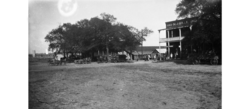
 Calhoun, 1928 Calhoun, 1928 | |
  | |
| Coordinates: 32°03′01″N 86°32′42″W / 32.05028°N 86.54500°W / 32.05028; -86.54500 | |
| Country | United States |
| State | Alabama |
| County | Lowndes |
| Elevation | 272 ft (83 m) |
| Time zone | UTC-6 (Central (CST)) |
| • Summer (DST) | UTC-5 (CDT) |
| Area code | 334 |
Calhoun is an unincorporated community in Lowndes County, Alabama, United States.
History
A post office operated under the name Calhoun from 1851 to 1973.
Calhoun was formerly home to the Calhoun Colored School, a private boarding and day school.
Ramah Baptist Church in Calhoun is listed on the Alabama Register of Landmarks and Heritage.
Notable natives
- Sidney Dickinson, painter
- William K. Payne, president of Georgia State College from 1949 until his death in 1963
- Tommy Sampson, second baseman in the Negro leagues
References
- U.S. Geological Survey Geographic Names Information System: Calhoun, Alabama
- "Lowndes County". Jim Forte Postal History. Retrieved March 1, 2020.
- Hasan Kwame Jeffries (July 1, 2009). Bloody Lowndes: Civil Rights and Black Power in Alabama’s Black Belt. NYU Press. p. 263. ISBN 978-0-8147-4306-5.
- "Alabama Register of Landmarks and Heritage". Alabama Historical Commission. Retrieved March 1, 2020.
| Municipalities and communities of Lowndes County, Alabama, United States | ||
|---|---|---|
| County seat: Hayneville | ||
| Towns |  | |
| Unincorporated communities | ||
This Lowndes County, Alabama state location article is a stub. You can help Misplaced Pages by expanding it. |