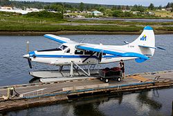
| Campbell River Water Aerodrome | |||||||||||
|---|---|---|---|---|---|---|---|---|---|---|---|
 | |||||||||||
| Summary | |||||||||||
| Airport type | Private | ||||||||||
| Operator | Corilair Charters Ltd. | ||||||||||
| Location | Campbell River, British Columbia | ||||||||||
| Time zone | PST (UTC−08:00) | ||||||||||
| • Summer (DST) | PDT (UTC−07:00) | ||||||||||
| Elevation AMSL | 0 ft / 0 m | ||||||||||
| Coordinates | 50°03′N 125°15′W / 50.050°N 125.250°W / 50.050; -125.250 | ||||||||||
| Map | |||||||||||
  | |||||||||||
| Runways | |||||||||||
| |||||||||||
| Source: Water Aerodrome Supplement | |||||||||||
Campbell River Water Aerodrome or Campbell River Harbour Airport, (IATA: YHH, TC LID: CAE3), is located adjacent to Campbell River, British Columbia, Canada.
The airport is classified as an airport of entry by Nav Canada and is staffed by the Canada Border Services Agency. CBSA officers at this airport can handle general aviation aircraft only, with no more than 15 passengers.
Airlines and destinations
| Airlines | Destinations |
|---|---|
| Corilair | Alert Bay, Arron Point, Blind Channel, Cortes Bay, Dent Island, Fredrick Arm, Gilford Island, Hernando Island, Lund, Owen Bay, Port McNeill, Powell River, Prideaux Heven, Refuge Cove, Sevary Island, Sonora Island, Stuart Island-Big Bay, Surge Narrows Seasonal: Vancouver |
See also
References
- ^ Nav Canada's Water Aerodrome Supplement. Effective 0901Z 26 March 2020 to 0901Z 22 April 2021.
- Accident history for Campbell River-Harbor SPB, BC (IATA: YHH) at Aviation Safety Network
- "Corilair Official Website". Retrieved January 20, 2014.
| Airports in Canada | |
|---|---|
| By name | |
| By location indicator | |
| By province/territory | |
| By area | |
| National Airports System | |
| Related | |
This article about an airport in British Columbia is a stub. You can help Misplaced Pages by expanding it. |