Human settlement in Scotland
Carnwath
| |
|---|---|
 The Carstairs meanders near Carnwath The Carstairs meanders near Carnwath | |
 | |
| Population | 1,360 (2022) |
| OS grid reference | NS979464 |
| Council area | |
| Lieutenancy area | |
| Country | Scotland |
| Sovereign state | United Kingdom |
| Post town | LANARK |
| Postcode district | ML11 |
| Dialling code | 01555 |
| Police | Scotland |
| Fire | Scottish |
| Ambulance | Scottish |
| UK Parliament | |
| Scottish Parliament | |
| Website | Visit Lanarkshire |
| 55°42′02″N 3°37′30″W / 55.70056°N 3.62500°W / 55.70056; -3.62500 | |
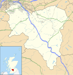
Carnwath (Gaelic: A' Chathair Nuadh; English: "New Fort") is a moorland village on the southern edge of the Pentland Hills of South Lanarkshire, Scotland. The village lies about 30 mi (50 km) south of both Edinburgh and Glasgow. It is bounded by the North Medwyn and South Medwyn watercourses.
History
Carnwath stands about a mile north of the old Roman road connecting forts in Tweeddale with those on the Clyde.
The former castle of Carnwath is believed to date to the mid 12th-century built under the orders of William de Sommerville (who died 1160). However, the only remains are the motte which is visible beside the Carnwath Golf Club (founded 1907), at the west end of the village. However, the motte is described as "the most impressive Norman earthwork to survive in Lanarkshire." The motte today is a scheduled ancient monument.
At the centre of Carnwath is Carnwath Cross, the mercat cross, set back a little where the Main Street widens to form the Market Square. This was erected by the 5th Lord Somerville in 1516 to celebrate the granting of burgh status to the village in 1514.
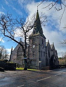
Carnwath collegiate church was established in 1386. The only surviving part of the original collegiate church is St Mary's Aisle, built in 1424 and funded by Thomas Somerville, 1st Lord Somerville (later used as a mausoleum for the Lord Somervilles). St Mary's Aisle is Category A listed. In 1869, a new parish church was built beside the earlier buildings to a design by the Scottish architect David Bryce. The church is Scottish baronial in style and is Category B listed. The church no longer functions as a place of worship.
In 1630, the Carnwath estate, then owned by the Earl of Mar was purchased by Sir Robert Dalzell, later to become Lord Dalzell. In 1639, his son, Robert the 2nd Lord Dalzell, was further elevated to become the Earl of Carnwath. The title was forfeit in 1716 when the 5th Earl of Carnwath, Robert Dalzell was attainted due to his support of the Jacobite cause during the Fifteen, however the titles were restored to the family in 1826. Writer, spy and politician, George Lockhart, inherited the Carnwath estates from his father, Sir George Lockhart, of the Lockharts of Lee, who had purchased them in 1681 from the Earls of Carnwath.
The Ordnance Gazetteer of Scotland (1882–1885) said the village was: "Long a dingy and disagreeable place, it has been greatly improved". In 1845 the area became a civil parish.
Other buildings of note in the village include the old primary school on Main Street, dated 1876 and abandoned since 2006.
A notable spell of cold weather
In January 1979 the temperature in Carnwath sank to −24.6 °C (−12.3 °F), which was the lowest temperature recorded anywhere in the British Isles in the 1970s.
Climate
| Climate data for Carnwath: 208 m (682 ft) 1991–2020 normals, extremes 1960–2006 | |||||||||||||
|---|---|---|---|---|---|---|---|---|---|---|---|---|---|
| Month | Jan | Feb | Mar | Apr | May | Jun | Jul | Aug | Sep | Oct | Nov | Dec | Year |
| Record high °C (°F) | 12.0 (53.6) |
13.5 (56.3) |
18.9 (66.0) |
25.8 (78.4) |
26.6 (79.9) |
30.1 (86.2) |
29.4 (84.9) |
29.8 (85.6) |
27.0 (80.6) |
21.7 (71.1) |
17.2 (63.0) |
13.0 (55.4) |
30.1 (86.2) |
| Mean daily maximum °C (°F) | 5.6 (42.1) |
6.3 (43.3) |
8.6 (47.5) |
11.3 (52.3) |
14.8 (58.6) |
16.9 (62.4) |
18.8 (65.8) |
18.7 (65.7) |
16.1 (61.0) |
11.8 (53.2) |
8.3 (46.9) |
5.5 (41.9) |
11.9 (53.4) |
| Daily mean °C (°F) | 2.4 (36.3) |
2.8 (37.0) |
4.7 (40.5) |
6.8 (44.2) |
9.6 (49.3) |
12.1 (53.8) |
13.9 (57.0) |
13.8 (56.8) |
11.5 (52.7) |
8.0 (46.4) |
4.8 (40.6) |
2.2 (36.0) |
7.7 (45.9) |
| Mean daily minimum °C (°F) | −0.8 (30.6) |
−0.7 (30.7) |
0.7 (33.3) |
2.2 (36.0) |
4.4 (39.9) |
7.4 (45.3) |
9.0 (48.2) |
8.8 (47.8) |
6.9 (44.4) |
4.1 (39.4) |
1.3 (34.3) |
−1.2 (29.8) |
3.5 (38.3) |
| Record low °C (°F) | −24.8 (−12.6) |
−21.2 (−6.2) |
−19.7 (−3.5) |
−9.0 (15.8) |
−7.6 (18.3) |
−3.8 (25.2) |
−1.2 (29.8) |
−2.2 (28.0) |
−5.5 (22.1) |
−9.9 (14.2) |
−14.6 (5.7) |
−20.0 (−4.0) |
−24.8 (−12.6) |
| Average precipitation mm (inches) | 86.7 (3.41) |
73.3 (2.89) |
64.0 (2.52) |
57.9 (2.28) |
54.0 (2.13) |
61.7 (2.43) |
71.1 (2.80) |
77.8 (3.06) |
71.1 (2.80) |
100.3 (3.95) |
89.4 (3.52) |
89.0 (3.50) |
896.3 (35.29) |
| Average precipitation days | 15.1 | 13.4 | 12.6 | 12.4 | 11.1 | 11.7 | 12.1 | 12.3 | 12.1 | 14.6 | 15.9 | 14.1 | 157.4 |
| Source 1: Météo Climat | |||||||||||||
| Source 2: KNMI (extremes) | |||||||||||||
Economy
There is a large production facility to the NE of the village belonging to BHC Building Merchants. In 2007, the company applied to extend the facility and an archaeological survey was completed beforehand.
The historic New/Wee Bush Inn was a former 18th century coaching inn that has been converted to housing. The inn buildings are category B listed. The Inn was damaged by fire in 2002 and was the last pub in Scotland to have a thatched roof. For insurance purposes it has had to be rebuilt with a slate roof. The Inn's former claim to fame was that actor Oliver Reed was a regular customer.
There are several other pubs in the village, as well as a COOP, corner store and DIY shop.
Transport

The A70 road and A721 roads meet in the town.
Carnwath has no current rail access. Carnwath railway station was originally part of the Caledonian Railway, later the London, Midland and Scottish Railway and finally the Scottish Region of British Railways, was closed in the Beeching Axe of the 1960s. The nearest railway station is Carstairs railway station to the west of Carnwath.
Education
There is a nursery school in the village which is part of the Biggar Learning Community, that includes the Biggar High School. A new primary school was built and opened in 2015.
Culture and community
Carnwath also hosts the oldest foot race in Scotland, possibly Europe, the Red Hose Race, dating back to 13 March 1508. It has seen many changes over almost 500 years, but the running of The Red Hose is still a strong tradition in Carnwath. Hose being the Scots word for stockings or long socks. Each year a foot race is run at Carnwath and the local Laird must provide a pair of red stockings as the prize.
The "Sir John Mann" park is a public park and open space in the village (formerly Medwyn Park).
There is a playing field (King George's Field) with a sports pavilion in the village. The site was built in 1935 and is Category B listed. The site was formerly used by Carnwath Bowls Club.
In popular culture
Carnwath is mentioned twice in the traditional song We're No' Awa' Tae Bide Awa', also known as Carnwath Mill.
So we had a hauf an' anither hauf,
And then we had anither,
When he got fou' he shouted
"Hoo!
It's Carnwath Mill for ever."
For we're no' awa' tae bide awa' , etc.
And:-
So whenever friendly friens may meet,
Wherever Scots foregather,
We'll raise our gless, we'll shout
Hurroo,
It's Carnwath Mill for ever.
The allusion is obscure. Carnwath Mill is a farm (and formerly, a mill) about 1 mile (1.5 kilometres) from Carnwath; alternatively, there was a lint mill at Carnwath erected in 1762; the former survives as a house and holiday let and The Lint Mill hosts a B&B and is an organic smallholding. The song also alludes to Wilsontown, which was about 6 miles (10 kilometres) away.
Notable people
Notable people from Carnwath include the first woman provost of Kirkintilloch, Jenny Coutts, the author and critic, Robert Anderson and the footballer, Tom Brownlee. The Ordnance Gazetteer remarks that: "the minor poet, James Graeme (1749–1772)" was a resident of the locality.
See also
- Caledonian Amateur Football League, Balmore who form part of the league play at Carnwath Village Park
- Lanark Blue, a locally made sheep's milk cheese
- Clydesdale East (ward), local government electoral ward containing the village
- Cobbinshaw Reservoir, a Site of Special Scientific Interest (SSSI)
References
- "Mid-2020 Population Estimates for Settlements and Localities in Scotland". National Records of Scotland. 31 March 2022. Retrieved 31 March 2022.
- Maxwell, G.S. (1976). "The Roman Road East of Castledykes, Lanarkshire". Glasgow Archaeological Journal. 5 (1): 93–98. Retrieved 6 March 2023., pp.93, 94.
- ^ Stevenson, J.B. (1985). Exploring Scotland's Heritage: The Clyde Estuary and Central Region. Edinburgh: Her Majesty's Stationery Office. p. 83. ISBN 011-4924546.
- Historic Environment Scotland. "Carnwath Golf Course, motte (SM1145)". Retrieved 20 February 2022.
- Historic Environment Scotland. "CARNWATH CROSS (LB694)". Canmore. Retrieved 19 February 2022.
- ^ Historic Environment Scotland. "ST MARY'S AISLE, INCLUDING GRAVEYARD, BOUNDARY WALLS AND RAILINGS, MAIN STREET, CARNWATH (LB692)". Canmore. Retrieved 19 February 2022.
- ^ Historic Environment Scotland. "CARNWATH PARISH CHURCH, MAIN STREET, CARNWATH (LB700)". Canmore. Retrieved 19 February 2022.
- "Carnwath Parish Church, Main Street, Carnwath". Church of Scotland. Retrieved 19 February 2022.
- ^ The Ordnance Gazetteer of Scotland
- "trevorharley.com". Archived from the original on 14 December 2015. Retrieved 12 December 2016.
- "United Kingdom climate normals 1991-2020". Météo Climat. Retrieved 8 April 2024.
- "KNMI - Carnwath minimum temperature time series". KNMI. Retrieved 8 April 2024.
- "Contact". BHC Building Merchants. Retrieved 20 February 2022.
- Historic Environment Scotland. "Carnwath, Medwyn Park (298238)". Canmore. Retrieved 20 February 2022.
- Historic Environment Scotland. "NEW BUSH INN (Category B Listed Building) (LB698)". Retrieved 20 February 2022.
- ^ "Thatched roof pub destroyed by fire". Herald Scotland. Retrieved 20 February 2022.
- Carnwath Primary School
- "Sir John Mann Park". South Lanarkshire Council. Retrieved 20 February 2022.
- Historic Environment Scotland. "BIGGAR ROAD, KING GEORGE'S PARK, CARNWATH SPORTS PAVILION (Category B Listed Building) (LB51593)". Retrieved 20 February 2022.
- "We're No' Awa' Tae Bide Awa' ". Traditional Scottish Songs. Retrieved 7 July 2020.
- McClain, N.E. (1970). "Scottish Lintmills, 1729–70". Textile History. 1 (3): 293–308. doi:10.1179/004049670793692545.
External links
- A local man's page of maps and photos
- Dunsyre.com and Dunsyre.net Information about Dunsyre and links to local pages.
- Dunysre Holiday Camp
- Carnwath Primary School
- St Mary's Aisle and Somerville Mausoleum, Carnwath
