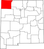
Unincorporated community in New Mexico, United States
| Cedar Hill, New Mexico | |
|---|---|
| Unincorporated community | |
 | |
| Coordinates: 36°56′13″N 107°53′25″W / 36.93694°N 107.89028°W / 36.93694; -107.89028 | |
| Country | United States |
| State | New Mexico |
| County | San Juan |
| Area | |
| • Total | 9.70 sq mi (25.12 km) |
| • Land | 9.40 sq mi (24.35 km) |
| • Water | 0.30 sq mi (0.77 km) |
| Elevation | 5,860 ft (1,790 m) |
| Population | |
| • Total | 1,130 |
| • Density | 120.21/sq mi (46.41/km) |
| Time zone | UTC-7 (Mountain (MST)) |
| • Summer (DST) | UTC-6 (MDT) |
| Area code | 505 |
| GNIS feature ID | 902202 |
Cedar Hill is an unincorporated community and census-designated place in San Juan County, New Mexico, United States. Its population was 847 as of the 2010 census. The community is located on U.S. Route 550, near the Colorado border. Cedar Hill was originally known as Cox's Crossing. The name was chosen during a Literacy Society meeting by picking names out of a hat. A post office operated from 1892 to 1966.
Geography
According to the U.S. Census Bureau, the community has an area of 5.561 square miles (14.40 km); 5.352 square miles (13.86 km) of its area is land, and 0.209 square miles (0.54 km) is water.
Demographics
| Census | Pop. | Note | %± |
|---|---|---|---|
| 2020 | 1,130 | — | |
| U.S. Decennial Census | |||
Education
The school district is Aztec Municipal Schools. Aztec High School is the local high school.
References
- "ArcGIS REST Services Directory". United States Census Bureau. Retrieved October 12, 2022.
- ^ U.S. Geological Survey Geographic Names Information System: Cedar Hill, New Mexico
- ^ "Census Population API". United States Census Bureau. Retrieved October 12, 2022.
- ^ "2010 Census Gazetteer Files - Places: New Mexico". U.S. Census Bureau. Retrieved December 21, 2016.
- Julyan, Robert (1996). The Place Names of New Mexico. University of New Mexico Press. p. 71. ISBN 0826316891.
- "Census of Population and Housing". Census.gov. Retrieved June 4, 2016.
- "2020 CENSUS - SCHOOL DISTRICT REFERENCE MAP: San Juan County, NM" (PDF). U.S. Census Bureau. Retrieved July 12, 2022.
| Municipalities and communities of San Juan County, New Mexico, United States | ||
|---|---|---|
| County seat: Aztec | ||
| Cities |  | |
| CDPs |
| |
| Other communities | ||
| Indian reservations | ||
| Footnotes | ‡This populated place also has portions in an adjacent county or counties | |
This New Mexico state location article is a stub. You can help Misplaced Pages by expanding it. |