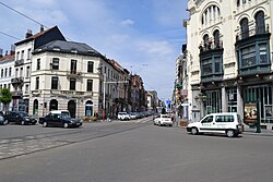
 View of the Ma Campagne crossroad with the Chaussée de Charleroi/Charleroisesteenweg View of the Ma Campagne crossroad with the Chaussée de Charleroi/Charleroisesteenweg | |
  | |
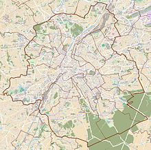
| Location | City of Brussels, Brussels-Capital Region, Belgium |
|---|---|
| Coordinates | 50°49′43″N 4°21′20″E / 50.82861°N 4.35556°E / 50.82861; 4.35556 |
The Chaussée de Charleroi (French, pronounced [ʃo.se d(ə) ʃaʁ.lə.ʁwa]) or Charleroisesteenweg (Dutch) is a major street in Brussels, Belgium, running through the municipalities of Saint-Gilles and the City of Brussels. It connects the Place Stéphanie/Stefanieplein in the City of Brussels to the Ma Campagne crossroad in Saint-Gilles. It forms the N261 road with the Avenue Brugmann/Brugmannlaan, the Rue de Stalle/Stallestraat and the Rue Prolongée de Stalle/Verlengde Stallestraat. It is named after the city of Charleroi (Wallonia).
Many bars, restaurants, hotels and shops are located on the Chaussée de Charleroi. The Brussels tram routes 92 and 97 also run on this street.
See also
References
- "Chaussée de Charleroi – Inventaire du patrimoine architectural". monument.heritage.brussels (in French). Retrieved 4 November 2023.
- "Chaussée de Charleroi – Inventaire du patrimoine architectural". monument.heritage.brussels (in French). Retrieved 4 November 2023.
External links
 Media related to Chaussée de Charleroi/Charleroisesteenweg (Brussels) at Wikimedia Commons
This Brussels location article is a stub. You can help Misplaced Pages by expanding it. |