Township in Ohio, United States
| Clearcreek Township, Warren County, Ohio | |
|---|---|
| Township | |
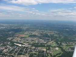
 Springboro, with unincorporated parts of Clearcreek Township visible in the distance Springboro, with unincorporated parts of Clearcreek Township visible in the distance | |
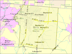
 Map of Clearcreek Township in Warren County Map of Clearcreek Township in Warren County | |
| Country | United States |
| State | Ohio |
| County | Warren |
| Government | |
| • Type | Board of Trustees |
| • President | Ed Wade |
| Area | |
| • Land | 45.8 sq mi (119 km) |
| Elevation | 958 ft (292 m) |
| Population | |
| • Total | 36,238 |
| Time zone | UTC-5 (Eastern (EST)) |
| • Summer (DST) | UTC-4 (EDT) |
| Area code | 513 |
| Website | https://www.clearcreektownship.com/ |

Clearcreek Township is one of the eleven townships of Warren County, Ohio, United States, located in the north central portion of the county. It had a population of 36,238 in 2020. It was originally about forty-two square miles in area. The highest point in the county is in Clearcreek Township, near the community of Five Points. Statewide, the only other Clearcreek Townships are located in Fairfield County and in Ashland County.
History
Clearcreek Township was organized in 1817, and named after its principal stream, Clear Creek.
Geography
Located in the northern part of the county, it borders the following townships:
- Washington Township, Montgomery County - northeast
- Wayne Township - east
- Turtlecreek Township - south
- Franklin Township - west
- Miami Township, Montgomery County - northwest
Much of the western portion of the township has been annexed by the city of Springboro.
Communities within Clearcreek Township include Five Points, Pekin, Red Lion, Ridgeville, Springboro, and Utica (near the intersection of Utica Road and Old Route 122).
Government

The township is governed by a three-member board of trustees, who are elected in November of odd-numbered years to a four-year term beginning on the following January 1. Two are elected in the year after the presidential election and one is elected in the year before it. There is also an elected township fiscal officer, who serves a four-year term beginning on April 1 of the year after the election, which is held in November of the year before the presidential election. Vacancies in the fiscal officership or on the board of trustees are filled by the remaining trustees.
Public services
Most of the township is in the Springboro Community City School District, but a large portion in the south central section is in the Lebanon City School District. Portions are also in the Franklin and Wayne school districts. The Springboro, Lebanon, Centerville and Waynesville post offices serve the township and it lies in the Franklin, Lebanon, Waynesville, Miamisburg, and Centerville telephone exchanges.
Interstate 75 runs through Clearcreek Township, as do State Routes 48, 73, and 741. A small portion of the City of Dayton's Wright Brothers Airport is in Clearcreek Township.
References
- "Clearcreek Township - Elected Officials". Clearcreek Township. Retrieved March 20, 2023.
- "US Board on Geographic Names". United States Geological Survey. October 25, 2007. Retrieved January 31, 2008.
- "Clear Creek township, Warren County, Ohio - Census Bureau Profile". United States Census Bureau. Retrieved March 20, 2023.
- "Warren County, Ohio Place Names". Warren County Genealogical Society. Archived from the original on March 13, 2018. Retrieved March 13, 2018.
- U.S. Geological Survey Geographic Names Information System: Clearcreek Township, Warren County, Ohio
- §503.24, §505.01, and §507.01 of the Ohio Revised Code. Accessed 4/30/2009.
External links
| Municipalities and communities of Warren County, Ohio, United States | ||
|---|---|---|
| County seat: Lebanon | ||
| Cities |  | |
| Villages | ||
| Townships | ||
| CDPs | ||
| Unincorporated communities |
| |
| Ghost towns | ||
| Footnotes | ‡This populated place also has portions in an adjacent county or counties | |
39°33′N 84°15′W / 39.550°N 84.250°W / 39.550; -84.250
Categories: