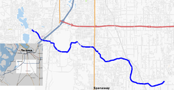
Clover Creek is a creek in Pierce County, Washington. Clover Creek rises near Frederickson, flows through Spanaway and Parkland, is diverted under the main runway of McChord Air Force Base and Interstate 5, and into Lakewood, where it spills into Lake Steilacoom.
The creek was named for the wild clover growing along its course. Its drainage basin is 74 square miles (190 km). The creek is 13.8 miles (22.2 km) long. Clover Creek was the traditional home of the Sastuck band of the Steilacoom Tribe of Indians.
References
- Meany, Edmond S. (1923). Origin of Washington geographic names. Seattle: University of Washington Press. p. 51.
- Clover Creek basin description Archived 2011-07-16 at the Wayback Machine, Pierce County Department of Public Works
- Steilacoom Tribe History Archived 2007-12-17 at archive.today, Steilacoom Tribal Cultural Center
External links
- U.S. Geological Survey Geographic Names Information System: Clover Creek
- USGS Real-Time Water Data for Clover Creek near Tillicum, WA
47°9′25″N 122°31′43″W / 47.15694°N 122.52861°W / 47.15694; -122.52861
This Pierce County, Washington state location article is a stub. You can help Misplaced Pages by expanding it. |
This article related to a river in the state of Washington is a stub. You can help Misplaced Pages by expanding it. |