Place in Eastern Cape, South Africa
| Coghlan | |
|---|---|
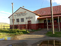
 Coghlan Trading Store and Post Office Coghlan Trading Store and Post Office | |
  | |
| Coordinates: 31°39′S 28°14′E / 31.650°S 28.233°E / -31.650; 28.233 | |
| Country | South Africa |
| Province | Eastern Cape |
| District | Chris Hani |
| Municipality | Engcobo |
| Area | |
| • Total | 1.47 km (0.57 sq mi) |
| Population | |
| • Total | 517 |
| • Density | 350/km (910/sq mi) |
| Time zone | UTC+2 (SAST) |
| Postal code (street) | 5054 |
| PO box | 5054 |
Coghlan is a small South African village in the Eastern Cape on the road between Ngcobo and Mthatha and due north from Xuka Drift on the Xuka River. The Xuka River and the Xinika River are the two main tributaries of the Mbashe River.
It has a guest house and village shop.
See also
References
- ^ "Sub Place Coghlan". Census 2001.
- "Xuka Drift, South Africa Atlas-Style Relief Map". Travelpost.com. Archived from the original on 27 September 2007.
- "Mbashe Catchment Generalised Land-cover". South African Estuaries: Catchment Land Cover. South African Department of Environmental Affairs and Tourism. Archived from the original on 8 October 2006.
External links
| Municipalities and communities of Chris Hani District Municipality, Eastern Cape | ||
|---|---|---|
| District seat: Queenstown (Komani) | ||
| Intsika Yethu |  | |
| Enoch Mgijima | ||
| Engcobo |
| |
| Emalahleni |
| |
| Inxuba Yethemba | ||
| Sakhisizwe | ||
This Eastern Cape location article is a stub. You can help Misplaced Pages by expanding it. |