| County of HorneGraofsjap Häör (Limburgish) Graafschap Horn (Dutch) | |||||||||||
|---|---|---|---|---|---|---|---|---|---|---|---|
| 920–1795 | |||||||||||
 Coat of arms
| |||||||||||
 Lordship of Horne (1350) Lordship of Horne (1350) | |||||||||||
| Status | County | ||||||||||
| Capital | Horn | ||||||||||
| Common languages | Limburgish, Dutch | ||||||||||
| Religion | Roman Catholicism | ||||||||||
| Historical era | Middle Ages | ||||||||||
| • Established | 920 | ||||||||||
| • Personal union | 1568 | ||||||||||
| • Annexed by France | 1795 | ||||||||||
| • Concordat | 10 September 1801 | ||||||||||
| |||||||||||


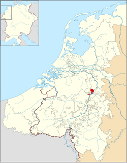
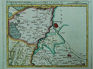
Horne (also Horn, Hoorn or Hoorne) is a small historic county of the Holy Roman Empire in the present day Netherlands and Belgium. It takes its name from the village Horn, west of Roermond. The residence of the counts of Horne was moved from Horn to Weert in the 15th century.
After the execution in 1568 of Philip de Montmorency who died without male heirs, the Prince-Bishop of Liège, as suzerain of Horne, was declared the direct lord and new count. The bishops ruled the county in personal union. Horne maintained its own laws and customs as well as its financial autonomy. The county included the communes of Neer, Nunhem, Haelen, Buggenum, Roggel, Heythuysen, Horne, Beegden, Geystingen and Ophoven.
It was suppressed in 1795, when it was occupied by the French, and it became part of the French département Meuse-Inférieure.
Rulers of Horne
Lords of Horne
- Engelbert de Hurne,
- Engelbert de Hurnen,
- Henry van Horn, † 1196
- William,
- Engelbert,
- Gerhard van Horn
- William I., † 1264/65,
- Engelbert van Horn, 1212/64
- William II., † 1300/1301,
- William III., † 1301,
- Gerhard I., † 1330,
- Willem IV of Horne (Lord 1330-1343)
- Gerard II of Horne (Lord 1343-1345)
- Willem V of Horne (Lord 1345-1357)
- Dirk Loef of Horne (Lord 1357-1368)
- Willem VI of Horne (Lord 1368-1405) † 1417,
- William VII., † 1433,
Counts of Horne
- Jacob I., † 1488,
- Jacob II., † 1530,
- Jacob III., X 1531,
- John, † 1540
- Philippe de Montmorency
- The prince-bishops of Liège, 1568-1795
References
- Bulletin de la Commission centrale de statistique, Brussels, 1857, vol. 7, p. 136.
Sources
- Detlev Schwennicke, Europäische Stammtafeln Band XVIII (1998) Tafel 62ff und Band XIV (1991) Tafel 122
| Prince-bishops |  | ||||||
|---|---|---|---|---|---|---|---|
| Prince-abbots | |||||||
| Secular | |||||||
| Counts / Lords |
| ||||||
| Cities | |||||||
| from 1648 until 1648 without seat in Imperial Diet status uncertain
Circles est. 1500: Bavarian, Swabian, Upper Rhenish, Lower Rhenish–Westphalian, Franconian, (Lower) Saxon
| |||||||
This Dutch-history-related article is a stub. You can help Misplaced Pages by expanding it. |
This Belgian history-related article is a stub. You can help Misplaced Pages by expanding it. |
- Limburg (region)
- History of Limburg (Netherlands)
- 1795 disestablishments in the Holy Roman Empire
- States and territories established in the 920s
- Counties of the Holy Roman Empire
- 920 establishments
- 10th-century establishments in the Holy Roman Empire
- Southern Netherlands
- Dutch history stubs
- European history stubs
- Belgium stubs