Misplaced Pages

County of Nares

Article snapshot taken from Wikipedia with creative commons attribution-sharealike license. Give it a read and then ask your questions in the chat. We can research this topic together.

Map all coordinates using OpenStreetMap

Download coordinates as:

Cadastral in Queensland, Australia
Nares
Queensland
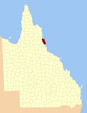
Location within Queensland
Lands administrative divisions around Nares:
Chelmsford Solander Pacific Ocean
Dagmar Nares Pacific Ocean
Hodgkinson Cardwell Pacific Ocean

The county of Nares is a cadastral division of Queensland which contains the city of Cairns, Innisfail and most of the Atherton Tableland. The county is divided into civil parishes. It was named after George Nares (1831–1915), a naval officer and commander of HMS Salamander. Cairns is mentioned as being in the county of Nares in the 1911 Britannica. It is bounded by the Daintree River in the north.

Parishes

Nares is subdivided into parishes, listed as follows:

Parish LGA Coordinates Towns
Barron Tablelands 17°15′S 145°29′E / 17.250°S 145.483°E / -17.250; 145.483 (Barron Parish) Atherton, Tolga
Bartle Frere Tablelands 17°25′S 145°45′E / 17.417°S 145.750°E / -17.417; 145.750 (Bartle Frere Parish)
Bellenden Ker Cairns 17°20′S 145°53′E / 17.333°S 145.883°E / -17.333; 145.883 (Bellenden Ker Parish) Babinda, Bellenden Ker, Miriwinni
Cairns Cairns 16°53′S 145°40′E / 16.883°S 145.667°E / -16.883; 145.667 (Cairns Parish) Cairns, Kuranda
Danbulla Tablelands 17°07′S 145°36′E / 17.117°S 145.600°E / -17.117; 145.600 (Danbulla Parish)
Dinden Mareeba 17°00′S 145°34′E / 17.000°S 145.567°E / -17.000; 145.567 (Dinden Parish)
Dirran Tablelands 17°30′S 145°37′E / 17.500°S 145.617°E / -17.500; 145.617 (Dirran Parish) Tarzali, Millaa Millaa
Dulanban Cairns 16°40′S 145°33′E / 16.667°S 145.550°E / -16.667; 145.550 (Dulanban Parish)
East Barron Tablelands 17°19′S 145°33′E / 17.317°S 145.550°E / -17.317; 145.550 (East Barron Parish) Yungaburra
Formartine Mareeba 16°52′S 145°29′E / 16.867°S 145.483°E / -16.867; 145.483 (Formartine Parish)
Gadgarra Tablelands 17°15′S 145°44′E / 17.250°S 145.733°E / -17.250; 145.733 (Gadgarra Parish)
Glady Cassowary Coast 17°28′S 145°56′E / 17.467°S 145.933°E / -17.467; 145.933 (Glady Parish) Flying Fish Point
Grafton Cairns 17°05′S 145°44′E / 17.083°S 145.733°E / -17.083; 145.733 (Grafton Parish) Edmonton, Gordonvale
Hull Cassowary Coast 17°47′S 146°00′E / 17.783°S 146.000°E / -17.783; 146.000 (Hull Parish) Silkwood, South Mission Beach, El Arish
Japoon Cassowary Coast 17°44′S 145°55′E / 17.733°S 145.917°E / -17.733; 145.917 (Japoon Parish) Japoon
Johnstone Cassowary Coast 17°36′S 145°55′E / 17.600°S 145.917°E / -17.600; 145.917 (Johnstone Parish) Innisfail, South Johnstone
Jordan Cassowary Coast 17°39′S 145°45′E / 17.650°S 145.750°E / -17.650; 145.750 (Jordan Parish)
Malanda Tablelands 17°22′S 145°37′E / 17.367°S 145.617°E / -17.367; 145.617 (Malanda Parish) Malanda
Monamona Mareeba 16°46′S 145°30′E / 16.767°S 145.500°E / -16.767; 145.500 (Monamona Parish)
Mourilyan Cassowary Coast 17°37′S 146°03′E / 17.617°S 146.050°E / -17.617; 146.050 (Mourilyan Parish) Mourilyan, parts of Innisfail
Palmerston Cassowary Coast 17°34′S 145°45′E / 17.567°S 145.750°E / -17.567; 145.750 (Palmerston Parish)
Russell Cairns 17°19′S 145°59′E / 17.317°S 145.983°E / -17.317; 145.983 (Russell Parish) Bramston Beach
Smithfield Tablelands 16°46′S 145°38′E / 16.767°S 145.633°E / -16.767; 145.633 (Smithfield Parish) Northern Beaches
Sophia Cairns 17°07′S 145°52′E / 17.117°S 145.867°E / -17.117; 145.867 (Sophia Parish) Aloomba
Tinaroo Mareeba 17°04′S 145°25′E / 17.067°S 145.417°E / -17.067; 145.417 (Tinaroo Parish) Mareeba, Walkamin
Trinity Cairns 16°58′S 145°49′E / 16.967°S 145.817°E / -16.967; 145.817 (Trinity Parish) Yarrabah

References

  1. Queensland showing counties / compiled and published at the Survey Department, Brisbane, Brisbane : Survey Dept., 1900.
  2. "Nares – county (entry 23870)". Queensland Place Names. Queensland Government. Retrieved 21 June 2017.
  3. Chisholm, Hugh, ed. (1911). "Cairns" . Encyclopædia Britannica. Vol. 4 (11th ed.). Cambridge University Press. p. 953.
  4. Cook District, County of Nares Maps - P9 Series Archived 2011-07-22 at the Wayback Machine at Queensland Archives.

External links

16°55′S 145°47′E / 16.917°S 145.783°E / -16.917; 145.783

Category: