Misplaced Pages

County of Plantagenet, Queensland

Article snapshot taken from Wikipedia with creative commons attribution-sharealike license. Give it a read and then ask your questions in the chat. We can research this topic together.

Cadastral in Queensland, Australia
Plantagenet
Queensland
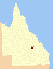
Location within Queensland
Lands administrative divisions around Plantagenet:
Belyando Clermont Clermont
Drummond Plantagenet Denison
Claude Buckland Buckland
Map all coordinates using OpenStreetMap

Download coordinates as:

The County of Plantagenet is one of the lands administrative divisions of Queensland that has existed since 1901. The county is divided into civil parishes. It is located in the Central Highlands Region of Central Queensland.

Parishes

It contains the following parishes:

Parish LGA Coordinates Towns
Anakie Central Highlands 23°30′S 147°51′E / 23.500°S 147.850°E / -23.500; 147.850 (Anakie Parish) Anakie
Argyll Central Highlands 23°28′S 147°26′E / 23.467°S 147.433°E / -23.467; 147.433 (Argyll Parish)
Ducabrook Central Highlands 23°55′S 147°20′E / 23.917°S 147.333°E / -23.917; 147.333 (Ducabrook Parish)
Dunstable Central Highlands 24°03′S 147°38′E / 24.050°S 147.633°E / -24.050; 147.633 (Dunstable Parish)
Echo Hills Central Highlands 24°03′S 147°26′E / 24.050°S 147.433°E / -24.050; 147.433 (Echo Hills Parish)
Glendarriwell Central Highlands 23°36′S 147°50′E / 23.600°S 147.833°E / -23.600; 147.833 (Glendarriwell Parish)
Kilsyth Central Highlands 24°03′S 147°15′E / 24.050°S 147.250°E / -24.050; 147.250 (Kilsyth Parish)
Maaland Central Highlands 24°09′S 147°09′E / 24.150°S 147.150°E / -24.150; 147.150 (Maaland Parish)
Medway Central Highlands 23°48′S 147°20′E / 23.800°S 147.333°E / -23.800; 147.333 (Medway Parish)
Narcissus Central Highlands 24°09′S 147°23′E / 24.150°S 147.383°E / -24.150; 147.383 (Narcissus Parish)
Raymond Central Highlands 24°09′S 147°37′E / 24.150°S 147.617°E / -24.150; 147.617 (Raymond Parish)
Riddell Central Highlands 23°43′S 147°47′E / 23.717°S 147.783°E / -23.717; 147.783 (Riddell Parish)
Rutland Central Highlands 23°53′S 147°41′E / 23.883°S 147.683°E / -23.883; 147.683 (Rutland Parish)
Southernwood Central Highlands 23°39′S 147°42′E / 23.650°S 147.700°E / -23.650; 147.700 (Southernwood Parish)
Tresswell Central Highlands 24°14′S 147°30′E / 24.233°S 147.500°E / -24.233; 147.500 (Tresswell Parish)
Wilford Central Highlands 23°50′S 147°33′E / 23.833°S 147.550°E / -23.833; 147.550 (Wilford Parish)
Withersfield Central Highlands 23°35′S 147°30′E / 23.583°S 147.500°E / -23.583; 147.500 (Withersfield Parish)
Woodbine Central Highlands 23°42′S 147°28′E / 23.700°S 147.467°E / -23.700; 147.467 (Woodbine Parish)
Zamia Central Highlands 23°37′S 147°18′E / 23.617°S 147.300°E / -23.617; 147.300 (Zamia Parish) Bogantungan

References

  1. Queensland showing counties / compiled and published at the Survey Department, Brisbane, Brisbane : Survey Dept., 1900.
  2. Leichhardt District, County of Plantagenet Maps – H8 Series at Queensland Archives.

23°34′S 147°35′E / 23.567°S 147.583°E / -23.567; 147.583


Stub icon

This Queensland location article is a stub. You can help Misplaced Pages by expanding it.

Categories: