| This article needs additional citations for verification. Please help improve this article by adding citations to reliable sources. Unsourced material may be challenged and removed. Find sources: "Curtis Park, Sacramento, California" – news · newspapers · books · scholar · JSTOR (March 2007) (Learn how and when to remove this message) |
| Curtis Park | |
|---|---|
| Neighborhood of Sacramento | |
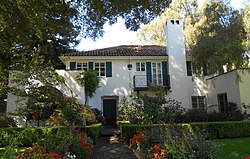
 J. C. Carly House J. C. Carly House | |
 | |
| Coordinates: 38°32′44″N 121°28′45″W / 38.54548°N 121.47922°W / 38.54548; -121.47922 | |
| Country | United States |
| State | California |
| County | Sacramento |
| City | Sacramento |
| ZIP Code | 95818 |
Curtis Park is a neighborhood located within the city of Sacramento, California. Curtis Park is defined as north of Sutterville Road, south of Broadway, east of Freeport Boulevard, and west of Highway 99. Curtis Park is a largely residential neighborhood. It is known for its charming vintage homes including Victorian, Bungalow, and 1920s revival style subdivisions. Information about the neighborhood can be obtained from the Sierra Curtis Neighborhood Association.
Utility providers
Notable residents
Traditionally one of the more well-to-do neighborhoods in the city proper, Curtis Park has been home to many of Sacramento's best known citizens.
- Ray Eames – Childhood home of the designer
- Roger Dickinson – Assemblyman
- Kevin Johnson – Former NBA star and mayor of Sacramento
- Dave Jones – California Insurance Commissioner, former State Assemblyman & Sacramento City Councilmember
- Gloria McLeod – California State Senator from Chino; keeps a home in Curtis Park
- Raphael Saadiq – Musician
- Joe Serna – The late mayor of Sacramento, lived here until his death
References
- Utilities Department. City of Sacramento. Retrieved 2011-02-26.
- Sacramento Municipal Utility District Archived 2010-03-14 at the Wayback Machine. Retrieved 2011-02-26.
