| De Weere | |
|---|---|
| Hamlet | |
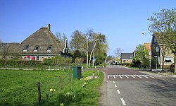
 View on De Weere View on De Weere | |
  | |
| Coordinates: 52°46′28″N 4°52′1″E / 52.77444°N 4.86694°E / 52.77444; 4.86694 | |
| Country | Netherlands |
| Province | North Holland |
| Municipality | Hollands Kroon |
| Time zone | UTC+1 (CET) |
| • Summer (DST) | UTC+2 (CEST) |
| Postal code | 1732 |
| Dialing code | 0224 |
De Weere (West Frisian: De Weare) is a hamlet in the Dutch province of North Holland. It is a part of the municipality of Hollands Kroon, and lies about 12 km north of Heerhugowaard.
De Weere is not a statistical entity, and the postal authorities have placed it under Lutjewinkel. It has no place name signs, and consists of about 25 houses.
References
- ^ "Postcode 1732 in Lutjewinkel". Postcode bij adres (in Dutch). Retrieved 30 April 2022.
- "Kerncijfers wijken en buurten 2021". Central Bureau of Statistics. Retrieved 30 April 2022.
not found
- "De Weere (Lutjewinkel)". Plaatsengids (in Dutch). Retrieved 30 April 2022.
| Populated places in the municipality of Hollands Kroon | |
|---|---|
| Towns | |
| Villages | |
| Hamlets | |
| List of cities, towns and villages in North Holland | |
This North Holland location article is a stub. You can help Misplaced Pages by expanding it. |