Unincorporated community in Minnesota, United States
| Dugdale | |
|---|---|
| Unincorporated community | |
  | |
| Coordinates: 47°42′06″N 96°15′59″W / 47.70167°N 96.26639°W / 47.70167; -96.26639 | |
| Country | United States |
| State | Minnesota |
| County | Polk |
| Elevation | 1,138 ft (347 m) |
| Time zone | UTC-6 (Central (CST)) |
| • Summer (DST) | UTC-5 (CDT) |
| Area code | 218 |
| GNIS feature ID | 654680 |
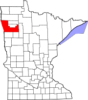
Dugdale is an unincorporated community in Polk County, Minnesota, United States. Dugdale is located at 47°42′06″N 96°15′59″W / 47.70167°N 96.26639°W / 47.70167; -96.26639.
The community is located east of Crookston and south of Red Lake Falls on Minnesota State Highway 32.
A post office called Dugdale was established in 1884, and remained in operation until 1927. Dugdale had a depot on the railroad.
References
- ^ U.S. Geological Survey Geographic Names Information System: Dugdale, Minnesota
- "Polk County". Jim Forte Postal History. Retrieved July 31, 2015.
- Upham, Warren (1920). Minnesota Geographic Names: Their Origin and Historic Significance. Minnesota Historical Society. p. 423.
| Municipalities and communities of Polk County, Minnesota, United States | ||
|---|---|---|
| County seat: Crookston | ||
| Cities |  | |
| Townships |
| |
| Unincorporated communities | ||
| Indian reservation | ||
| Footnotes | ‡This populated place also has portions in an adjacent county or counties | |
This article about a location in Polk County, Minnesota is a stub. You can help Misplaced Pages by expanding it. |