| This article needs additional citations for verification. Please help improve this article by adding citations to reliable sources. Unsourced material may be challenged and removed. Find sources: "Dundonnell River" – news · newspapers · books · scholar · JSTOR (January 2022) (Learn how and when to remove this message) |
River in Scotland
| Dundonnell River | |
|---|---|
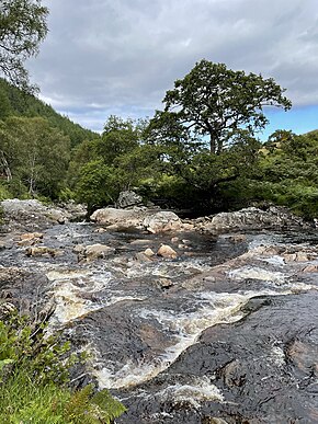
 The Dundonnell River at Airigh Ghiorid The Dundonnell River at Airigh Ghiorid | |
| Location | |
| Country | Scotland |
| Physical characteristics | |
| Source | |
| • location | Meall Dubh |
| • coordinates | 57°43′23″N 5°11′30″W / 57.723000°N 5.191793°W / 57.723000; -5.191793 |
| • elevation | 2,356 ft (718 m) |
| Mouth | |
| • location | Little Loch Broom |
| • coordinates | 57°50′56″N 5°13′21″W / 57.848970979581765°N 5.22251814648912°W / 57.848970979581765; -5.22251814648912 |
| • elevation | 0 ft (0 m) |
| Length | 14.4 mi (23.2 km) |
The Dundonnell River is a river in Ross and Cromarty, in the Scottish Highlands.
The river rises in a lochan on the slopes of Meall Dubh, before flowing north into the Dundonnell Forest. The A832 road follows its course roughly NNW, before the river flows through Strath Beag and meets Little Loch Broom at its estuary just north-west of Dundonnell.
References
- Ordnance Survey. OS Maps Online (Map). 1:25,000. Leisure. Retrieved 8 December 2021.
This article related to a river in Scotland is a stub. You can help Misplaced Pages by expanding it. |