Place in Northern Ireland, United Kingdom
| Dungannon Upper Dún Geanainn Uachtarach (Irish) | |
|---|---|
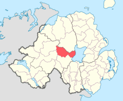
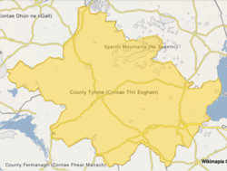
 Location of Dungannon Upper, County Tyrone, Northern Ireland. Location of Dungannon Upper, County Tyrone, Northern Ireland. | |
  | |
| Coordinates: 54°39′09″N 6°45′17″W / 54.6525°N 6.7548°W / 54.6525; -6.7548 | |
| Sovereign state | United Kingdom |
| Country | Northern Ireland |
| County | Tyrone |
Dungannon Upper is a barony in County Tyrone, Northern Ireland. It was created in 1851 with the splitting of the barony of Dungannon. Lough Neagh runs along its eastern boundary, and it is bordered by four other baronies: Dungannon Middle to the south; Loughinsholin to the north; Strabane Upper to the north-west; and Omagh East to the south-west.
List of main settlements
List of civil parishes
Below is a list of civil parishes in Dungannon Upper:
- Arboe (split with barony of Loughinsholin)
- Artrea (split with barony of Loughinsholin)
- Ballinderry (split with barony of Loughinsholin)
- Ballyclog
- Derryloran (split with barony of Loughinsholin)
- Desertcreat
- Kildress
- Lissan (also partly in barony of Loughinsholin)
- Tamlaght (split with barony of Loughinsholin)
References
- "Dungannon Upper". Placenames Database of Ireland. Department of Community, Rural and Gaeltacht Affairs. Retrieved 4 December 2012.
- ^ PRONI Baronies of Northern Ireland
- "Notes on Baronies of Ireland 1821-1891, page 14" (PDF). Archived from the original (PDF) on 12 March 2016. Retrieved 8 October 2010.
- "PRONI Parishes of County Tyrone". Archived from the original on 27 July 2011. Retrieved 15 July 2010.