Town in Louisiana, United States
| Elton, Louisiana | |
|---|---|
| Town | |
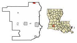
 Location of Elton in Jefferson Davis Parish, Louisiana Location of Elton in Jefferson Davis Parish, Louisiana | |
 Location of Louisiana in the United States Location of Louisiana in the United States | |
| Coordinates: 30°28′51″N 92°41′47″W / 30.48083°N 92.69639°W / 30.48083; -92.69639 | |
| Country | United States |
| State | Louisiana |
| Parish | Jefferson Davis |
| Government | |
| • Mayor | Kesia Lemoine |
| Area | |
| • Total | 1.66 sq mi (4.30 km) |
| • Land | 1.66 sq mi (4.30 km) |
| • Water | 0.00 sq mi (0.00 km) |
| Elevation | 49 ft (15 m) |
| Population | |
| • Total | 992 |
| • Density | 597.23/sq mi (230.60/km) |
| Time zone | UTC-6 (CST) |
| • Summer (DST) | UTC-5 (CDT) |
| ZIP code | 70532 |
| Area code | 337 |
| FIPS code | 22-23620 |
| Website | townofelton |
Elton is a town in Jefferson Davis Parish, Louisiana, United States. The population was 992 at the 2020 census, down from 1,128 at the 2010 census. It is part of the Jennings Micropolitan Statistical Area.
History
The wife of pioneer settler J. M. Henderson is said to have chosen the name "Elton" for her home town from a book in which she read of an English town named Elton. That was probably the town on the northwest coast of England in County Durham near Middlesbrough. Elton, Louisiana, was incorporated as a village in 1911.
Geography
Elton is in northeast Jefferson Davis Parish and is bordered to the north by Allen Parish. U.S. Route 190 passes through the town, leading east 16 miles (26 km) to Eunice and west 9 miles (14 km) to Kinder. Jennings, the Jefferson Davis Parish seat, is 26 miles (42 km) to the south of Elton via Louisiana Highway 26.
According to the United States Census Bureau, the town of Elton has a total area of 1.7 square miles (4.3 km), all land.
Demographics
| Census | Pop. | Note | %± |
|---|---|---|---|
| 1920 | 995 | — | |
| 1930 | 742 | −25.4% | |
| 1940 | 901 | 21.4% | |
| 1950 | 1,434 | 59.2% | |
| 1960 | 1,595 | 11.2% | |
| 1970 | 1,598 | 0.2% | |
| 1980 | 1,450 | −9.3% | |
| 1990 | 1,277 | −11.9% | |
| 2000 | 1,261 | −1.3% | |
| 2010 | 1,128 | −10.5% | |
| 2020 | 992 | −12.1% | |
| U.S. Decennial Census | |||
| Race | Number | Percentage |
|---|---|---|
| White (non-Hispanic) | 493 | 49.7% |
| Black or African American (non-Hispanic) | 369 | 37.2% |
| Native American | 32 | 3.23% |
| Asian | 6 | 0.6% |
| Other/Mixed | 66 | 6.65% |
| Hispanic or Latino | 26 | 2.62% |
As of the 2020 United States census, there were 992 people, 504 households, and 291 families residing in the town.
Education
Jefferson Davis Parish Public Schools operates public schools in Elton. Schools serving Elton, within Elton, include Elton Elementary School (PK-5) and Elton High School (6-12).
Jefferson Davis Parish Library operates the Elton Branch at 813 Main Street.
Notable people
- Al Woods- American football player for the New York Jets
- Leo Thomas, Zydeco drummer and vocalist
- Leroy Thomas, Zydeco vocalist and musician known as "The Jewel of the Bayou." Son of Leo Thomas
- Joseph F. Fuselier, first sheriff of Jefferson Davis Parish
- Lorena Langley Coushatta basket maker
References
- "Lemoine is Elton's newest mayor". December 11, 2022.
- "2020 U.S. Gazetteer Files". United States Census Bureau. Retrieved March 20, 2022.
- "Elton LA ZIP Code". zipdatamaps.com. 2023. Retrieved June 16, 2023.
- "Explore Census Data".
- ^ "Geographic Identifiers: 2010 Census Summary File 1 (G001): Elton town, Louisiana". American Factfinder. U.S. Census Bureau. Archived from the original on February 13, 2020. Retrieved June 28, 2018.
- "www.carencrohighschool.org "Elton named for town in Middlesbrough, England"". Archived from the original on August 1, 2012. Retrieved July 6, 2008.
- "Census of Population and Housing". Census.gov. Retrieved June 4, 2015.
- "Explore Census Data". data.census.gov. Retrieved December 29, 2021.
- "Schools". Jefferson Davis Parish Schools. Retrieved March 26, 2017.
External links
- Official website
- Hornet (August 8, 2008). "Hathaway, Louisiana: Elton". Hathaway, Louisiana. Retrieved May 17, 2024.
| Municipalities and communities of Jefferson Davis Parish, Louisiana, United States | ||
|---|---|---|
| Parish seat: Jennings | ||
| Cities |  | |
| Towns | ||
| Villages | ||
| CDPs | ||
| Other unincorporated communities |
| |
| Footnotes | +This populated place also has portions in an adjacent county or counties | |