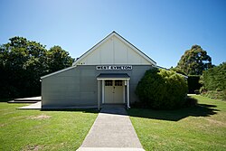
Village in South Island, New Zealand
| Eyreton | |
|---|---|
| village | |
 | |
| Coordinates: 43°24′54.3″S 172°32′39.3″E / 43.415083°S 172.544250°E / -43.415083; 172.544250 | |
| Country | New Zealand |
| Island | South Island |
| Region | Canterbury |
| Ward | Oxford-Ohoka Ward |
| Time zone | UTC+12 (NZST) |
| • Summer (DST) | UTC+13 (NZDT) |
Eyreton, originally known as Eyretown, is a small village in the Canterbury region of New Zealand's South Island. It is named after Edward John Eyre, who at one time was the lieutenant governor of the South Island (then known as New Munster). It is a rural village located to the west of Kaiapoi, near the north bank of the Waimakariri River.
Although a branch line railway called the Eyreton Branch existed, it never actually ran through Eyreton; its route from Kaiapoi to West Eyreton passed north of the village.
Demographics
Eyreton is part of the wider Swannanoa-Eyreton statistical area.
References
External links
| The territorial authority of Waimakariri District, Canterbury, New Zealand | |||||||||||
|---|---|---|---|---|---|---|---|---|---|---|---|
| Populated places; seat: Rangiora • Waimakariri District Council | |||||||||||
| Kaiapoi-Woodend Ward |
| ||||||||||
| Oxford-Ohoka Ward |
| ||||||||||
| Rangiora-Ashley Ward |
| ||||||||||
| Schools |
| ||||||||||
| Facilities | |||||||||||
| Sports clubs | |||||||||||
| Electorates |
| ||||||||||
| Member of Parliament |
| ||||||||||
| Mayor |
| ||||||||||
| Bodies of water | |||||||||||
| Transportation | |||||||||||
| Other | |||||||||||
| bold - main town; bold & italics - minor town; normal text - locality; italics - minor locality | |||||||||||
| Waimakariri River | |
|---|---|
| Source: Mount Rolleston, Southern Alps—Flows into: Pacific Ocean | |
| Administrative areas | |
| Towns and settlements (upstream to downstream) | |
| Major tributaries (upstream to downstream by confluence) | |
| Lakes in catchment (upstream to downstream by location or tributary) | |
| Other features (upstream to downstream) | |
| Longest New Zealand rivers |
|