| Folarskardnuten | |
|---|---|
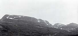
 Folarskardnuten seen from Rakstein valley Folarskardnuten seen from Rakstein valley | |
| Highest point | |
| Elevation | 1,933 m (6,342 ft) |
| Prominence | 917 m (3,009 ft) |
| Isolation | 86.7 to 86.9 km (53.9 to 54.0 mi) |
| Listing | 6 at List of highest points of Norwegian counties |
| Coordinates | 60°36′35.66″N 7°43′21.70″E / 60.6099056°N 7.7226944°E / 60.6099056; 7.7226944 |
| Geography | |
| Location | Hol, Buskerud, Norway |
| Parent range | Hallingskarvet |
| Topo map | 1516 III Hallingskarvet |
Folarskardnuten is the highest point on Hallingskarvet, and is also the highest point in the county Buskerud of Norway.
The mountain lies within Hallingskarvet National Park, Hol Municipality.
Further information on a stone mountain hut on Folarskardet: LordehyttaSee also
References
This article about a mountain, mountain range, or peak in Buskerud is a stub. You can help Misplaced Pages by expanding it. |