Statutory Town in Colorado, United States
| Fowler, Colorado | |
|---|---|
| Statutory Town | |
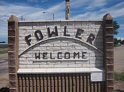
 Welcome Sign (2010) Welcome Sign (2010) | |
| Motto: "A Great Place to Grow" | |
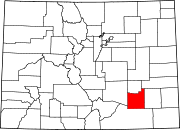
 Location of the Town of Fowler in Otero County, Colorado Location of the Town of Fowler in Otero County, Colorado | |
  | |
| Coordinates: 38°07′45″N 104°01′24″W / 38.1292°N 104.0233°W / 38.1292; -104.0233 | |
| Country | |
| State | |
| County | Otero |
| Incorporated (town) | August 25, 1925 |
| Area | |
| • Total | 0.563 sq mi (1.458 km) |
| • Land | 0.000 sq mi (0.000 km) |
| • Water | 0.559 sq mi (1.448 km) |
| Elevation | 4,341 ft (1,323 m) |
| Population | |
| • Total | 1,253 |
| • Density | 2,241/sq mi (865/km) |
| Time zone | UTC−07:00 (MST) |
| • Summer (DST) | UTC−06:00 (MDT) |
| ZIP code | 81039 |
| Area code | 719 |
| FIPS code | 08-27975 |
| GNIS ID | 204802 |
| Website | www |
Fowler is a statutory town located in northwestern Otero County, Colorado, United States. The town population was 1,253 at the 2020 United States Census.
History
Fowler was established as a railroad station on the Atchison, Topeka and Santa Fe Railway. The town was originally named Oxford, for a large ox that was killed when crossing the railroad tracks. The Oxford, Colorado, post office opened on April 27, 1882, but the name was changed to Fowler on on September 6, 1890. Fowler was named for Orson Squire Fowler, a phrenologist who founded the town. The Town of Fowler was incorporated on August 25, 1900.
Geography
Fowler is located along the Arkansas River and U.S. highway route 50 at coordinates 38°07′45″N 104°01′24″W / 38.1292°N 104.0233°W / 38.1292; -104.0233.
At the 2020 United States Census, the town had a total area of 360 acres (1.458 km), including 2.5 acres (0.010 km) of water.
Demographics
| Census | Pop. | Note | %± |
|---|---|---|---|
| 1910 | 925 | — | |
| 1920 | 1,062 | 14.8% | |
| 1930 | 968 | −8.9% | |
| 1940 | 922 | −4.8% | |
| 1950 | 1,025 | 11.2% | |
| 1960 | 1,240 | 21.0% | |
| 1970 | 1,241 | 0.1% | |
| 1980 | 1,227 | −1.1% | |
| 1990 | 1,154 | −5.9% | |
| 2000 | 1,206 | 4.5% | |
| 2010 | 1,182 | −2.0% | |
| 2020 | 1,253 | 6.0% | |
| U.S. Decennial Census | |||
As of the census of 2000, there were 1206 people, 521 households, and 330 families residing in the town. The population density was 2,468.5 inhabitants per square mile (953.1/km). There were 591 housing units at an average density of 1,209.7 per square mile (467.1/km). The racial makeup of the town was 95.02% White, 0.08% Black, 1.08% Native American, 0.17% Asian, 2.99% from other races, and 0.66% from two or more races. Latino or Hispanic of any race were 12.35% of the population.
There were 521 households, out of which 25.9% had children under the age of 18 living with them, 52.8% were married couples living together, 7.7% had a female householder with no husband present, and 36.5% were non-families. 34.5% of all households were made up of individuals, and 16.3% had someone living alone who was 65 years of age or older. The average household size was 2.22 and the average family size was 2.87.
In the town, the population was spread out, with 22.3% under the age of 18, 7.5% from 18 to 24, 22.5% from 25 to 44, 23.1% from 45 to 64, and 24.6% who were 65 years of age or older. The median age was 43 years. For every 100 females, there were 84.4 males. For every 100 females age 18 and over, there were 79.2 males.
The median income for a household in the town was $25,761, and the median income for a family was $32,143. Males had a median income of $25,536 versus $20,750 for females. The per capita income for the town was $15,501. About 11.3% of families and 11.9% of the population were below the poverty line, including 13.0% of those under age 18 and 9.3% of those age 65 or over.
Government
The town has a small police department and fire department. In 1998, the magazine Westword included Fowler among examples of small police departments that struggled to hire or retain their police chiefs. Police chief Floyd Rogers was fired in 1997 after a string of controversies regarding the department's treatment of adolescents. After his firing a crowd of 60 adolescents rioted in Fowler, barricading U.S. Route 50, setting fires, and vandalizing the police station and two police cars.
Education
The Fowler School District has one elementary school and one high school. The high school mascot is the Grizzlies.
Transportation
Fowler is part of Colorado's Bustang network. It is along the Lamar-Pueblo-Colorado Springs Outrider line.
Notable people
- Luke Hochevar, Major League Baseball pitcher (2007–present); raised in Fowler and pitched at Fowler High School.
Gallery
-
 Aerial view of the Arkansas River at Fowler
-
Fowler State Bank building
-
Fowler Fire Department and City Hall on U.S. Highway 50
-
First Methodist Church of Fowler
-
Fowler Historical Society
See also
- Bibliography of Colorado
- Geography of Colorado
- History of Colorado
- Index of Colorado-related articles
- List of Colorado-related lists
- Outline of Colorado
References
- ^ "Active Colorado Municipalities". Colorado Department of Local Affairs. Retrieved December 29, 2024.
- "Colorado Counties". State of Colorado, Colorado Department of Local Affairs, Division of Local Government. Retrieved December 29, 2024.
- "Home Page | Fowler CO". Town of Fowler.
- ^ "Fowler, Colorado". Geographic Names Information System. United States Geological Survey, United States Department of the Interior. Retrieved December 29, 2024.
- ^ "Colorado Municipal Incorporations". State of Colorado, Department of Personnel & Administration, Colorado State Archives. December 1, 2004. Retrieved September 2, 2007.
- ^ "Decennial Census P.L. 94-171 Redistricting Data". United States Census Bureau, United States Department of Commerce. August 12, 2021. Retrieved September 27, 2021.
- "ZIP Code Lookup". United States Postal Service. Archived from the original (JavaScript/HTML) on November 4, 2010. Retrieved October 19, 2015.
- "History". Fowler, Colorado. Retrieved July 12, 2012.
- Dawson, John Frank. Place names in Colorado: why 700 communities were so named, 150 of Spanish or Indian origin. Denver, CO: The J. Frank Dawson Publishing Co. p. 22.
- "U.S. Census website". United States Census Bureau. Retrieved January 31, 2008.
- Steven R. Wasserman; Jacqueline Wasserman Monroe; Bonnie Shaw Pfaff, eds. (1997). Law and legal information directory (9 ed.). Detroit, Mich.: Gale Research Co. ISBN 0-8103-4896-9. OCLC 35334976.
- "Contact Us". Fowler, Colorado. Retrieved March 4, 2023.
- Perez-Giese, Tony (February 26, 1998). "Hell to the Chiefs". Westword. Retrieved March 4, 2023.
- "Bustang Schedule". RideBustang. CDOT.
- Devlin, Neil H. (May 3, 2007). "The last Hochevar could be the best". The Denver Post. Retrieved July 4, 2022.
External links
| Municipalities and communities of Otero County, Colorado, United States | ||
|---|---|---|
| County seat: La Junta | ||
| Cities |  | |
| Towns | ||
| CDPs | ||
| Unincorporated communities | ||
| Ghost town | ||
| Trading posts | ||