Census-designated place & Unincorporated community in North Dakota, United States
| Foxholm, North Dakota | |
|---|---|
| Census-designated place & Unincorporated community | |
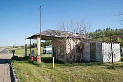
 Abandoned Gas Station in Foxholm Abandoned Gas Station in Foxholm | |
 | |
| Coordinates: 48°21′55″N 101°34′20″W / 48.36528°N 101.57222°W / 48.36528; -101.57222 | |
| Country | United States |
| State | North Dakota |
| County | Ward |
| Area | |
| • Total | 0.96 sq mi (2.48 km) |
| • Land | 0.96 sq mi (2.48 km) |
| • Water | 0.00 sq mi (0.00 km) |
| Elevation | 1,677 ft (511 m) |
| Population | |
| • Total | 56 |
| • Density | 58.39/sq mi (22.54/km) |
| Time zone | UTC-6 (Central (CST)) |
| • Summer (DST) | UTC-5 (CDT) |
| Area code | 701 |
| GNIS feature ID | 2584343 |
Foxholm is a census-designated place and unincorporated community in Ward County, North Dakota, United States. Its population was 75 as of the 2010 census.
Foxholm is located along U.S. Route 52, 18 miles (29 km) northwest of Minot and 76 miles (122 km) southeast of the Saskatchewan and North Dakota border at Portal, ND/North Portal, SK. Foxholm is in the Des Lacs River Valley.
A post office called Foxholm was established in 1894, and remained in operation until 1967. The community supposedly was named after a place in England.
Demographics
| Census | Pop. | Note | %± |
|---|---|---|---|
| 2020 | 56 | — | |
| U.S. Decennial Census | |||
References
- "ArcGIS REST Services Directory". United States Census Bureau. Retrieved September 20, 2022.
- ^ U.S. Geological Survey Geographic Names Information System: Foxholm, North Dakota
- "U.S. Census website". United States Census Bureau. Retrieved May 14, 2011.
- "Ward County". Jim Forte Postal History. Retrieved October 22, 2015.
- Federal Writers' Project (1938). North Dakota, a Guide to the Northern Prairie State. WPA. p. 275. ISBN 978-1-62376-033-5.
- "Census of Population and Housing". Census.gov. Retrieved June 4, 2016.
| Municipalities and communities of Ward County, North Dakota, United States | ||
|---|---|---|
| County seat: Minot | ||
| Cities |  | |
| Townships |
| |
| CDPs | ||
| Other community | ||
| Indian reservation | ||
| Footnotes | ‡This populated place also has portions in an adjacent county or counties | |
This North Dakota location article is a stub. You can help Misplaced Pages by expanding it. |