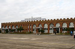
| Gondar Atse Tewodros Airport የጎንደር ዓፄ ቴዎድሮስ የአየር ማረፊያ | |||||||||||
|---|---|---|---|---|---|---|---|---|---|---|---|
 | |||||||||||
| Summary | |||||||||||
| Airport type | Public | ||||||||||
| Operator | Ethiopian Airports Enterprise | ||||||||||
| Serves | Gondar, Ethiopia | ||||||||||
| Elevation AMSL | 1,994 m / 6,542 ft | ||||||||||
| Coordinates | 12°31′11″N 037°26′02″E / 12.51972°N 37.43389°E / 12.51972; 37.43389 | ||||||||||
| Map | |||||||||||
 | |||||||||||
| Runways | |||||||||||
| |||||||||||
| Sources: | |||||||||||
Gondar Airport (IATA: GDQ, ICAO: HAGN), also known as Atse Tewodros Airport, is a public airport serving Gondar, a city in the northern Amhara Region of Ethiopia. The name of the city and airport may also be transliterated as Gonder. The airport is located 18 km (11 miles) south of Gondar. The airport is named after the 19th century Emperor of Ethiopia (Atse) Tewodros II.
Facilities
Gondar airport is at an elevation of 1,994 metres (6,542 ft) above mean sea level. It has one runway designated 17/35, with an asphalt surface measuring 2,700 by 45 metres (8,858 ft × 148 ft).
Airlines and destinations
| Airlines | Destinations |
|---|---|
| Ethiopian Airlines | Addis Ababa, Axum, Lalibela |
References
- ^ "Gondar Atse Tewodros Airport". Ethiopian Airports Enterprise. Archived from the original on 3 December 2013. Retrieved 21 July 2012.
- ^ Airport information for HAGN from DAFIF (effective October 2006)
- ^ Airport information for GDQ at Great Circle Mapper. Source: DAFIF (effective October 2006).
- "Domestic Route Map". Ethiopian Airlines. Archived from the original on 2011-09-30. Retrieved 2009-07-31.
External links
![]() Media related to Gondar Airport at Wikimedia Commons
Media related to Gondar Airport at Wikimedia Commons
| Main airports in Ethiopia | |
|---|---|
| International | |
| Domestic | |
| Military | |