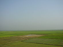

Hakaluki Haor (Bengali: হাকালুকি হাওর) is a marsh wetland ecosystem of north-eastern Bangladesh. It is one of Bangladesh's largest and one of Asia's large marsh wetland resources. The haor is bounded by the Kushiara river as well as a part of the Sonai Bardal river to the north, by the Fenchuganj-Kulaura railway to the west and to the south, and by the Kulaura-Beanibazar road the east. It lies between 24°35’ N to 24°44’ N and 92°00’ E to 92°08’ E.
A total of 558 species of animals and birds have been identified here, including some very rare – already declared as threatened, vulnerable, endangered and critically endangered species. Some 190,000 people live in the surrounding Hakaluki haor area. Hakaluki Haor is designated an Ecologically Critical Area (ECA).
The surface area of Hakaluki Haor is 181.15 km, of which 72.46 km (40.01%) is within the territory of Barlekha Upazila. It is also under Kulaura and Juri upazila of Moulvibazar District and Golapganj, Fenchuganj upazila of Sylhet district.
See also
References
- ^ Nixon Talukder and Sanzida Murshed (2012). "Hakaluki Haor". In Sirajul Islam; Miah, Sajahan; Khanam, Mahfuza; Ahmed, Sabbir (eds.). Banglapedia: the National Encyclopedia of Bangladesh (Online ed.). Dhaka, Bangladesh: Banglapedia Trust, Asiatic Society of Bangladesh. ISBN 984-32-0576-6. OCLC 52727562. OL 30677644M. Retrieved 13 January 2025.
- Choudhury, G. A., Nishat, A. Hydro-meteorological characteristics of Hakaluki Haor. IUCN Bangladesh Country Office. Dhaka. 2005. ISBN 984-8574-23-9 ""
- "Ecologically Critical Area", M. Aminul Islam, Banglapedia
24°30′N 91°50′E / 24.500°N 91.833°E / 24.500; 91.833
| Moulvibazar District | ||
|---|---|---|
| Capital: Moulvibazar | ||
| Upazilas | ||
| Constituencies | ||
| Attractions and sites | ||
| Mosques | ||
| Rivers | ||
| Inhabited areas | ||
| Educational institutions | ||
| Transport | ||
| History | ||