| This article needs additional citations for verification. Please help improve this article by adding citations to reliable sources. Unsourced material may be challenged and removed. Find sources: "Hampden, Newfoundland and Labrador" – news · newspapers · books · scholar · JSTOR (January 2022) (Learn how and when to remove this message) |
| Hampden | |
|---|---|
| Town | |
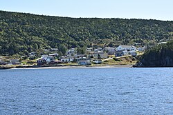
 Hampden from the White Bay Hampden from the White Bay | |
  | |
| Coordinates: 49°31′59″N 56°52′01″W / 49.533°N 56.867°W / 49.533; -56.867 | |
| Country | |
| Province | |
| The Town of Hampden | December 1959 |
| Named for | John Hampden |
| Government | |
| • Mayor | Calvin Wilton |
| • Member of the Newfoundland & Labrador House of Assembly | Andrew Furey (LIB) |
| • Members of the Canadian House of Commons | Gudie Hutchings (LIB) |
| Area | |
| • Total | 32.9 km (12.7 sq mi) |
| Elevation | 100 m (300 ft) |
| Population | |
| • Total | 439 |
| Time zone | UTC-3:30 (Newfoundland Time) |
| • Summer (DST) | UTC-2:30 (Newfoundland Daylight) |
| Postal Code | A0K 2Y0 |
| Area code | 709 |
| Highways | |
Hampden is a town in the Canadian province of Newfoundland and Labrador. The town has a population of 429. Two islands can be seen from the shore of Hampden, Granby Island and Millers Island. The latter is much closer to the town and is the host of a tuberculosis grave-site.
History
Hampden was named after English politician John Hampden.
Many communities were resettled into Hampden after the island was brought into Canadian Confederation on 31 March 1949, where the Joey Smallwood government pushed a resettlement plan that involved over 300 villages and 28,000 people.
Hampden was and still is to this day a logging and lumber town. Over the years many companies cut logs for lumber mills and pulpwood for paper mills. Thousands of cords of wood was boomed to the Bottom(furthest point south in White Bay) at an early time (1920s - 1930s) it was debarked and loaded aboard ships for England for the International Paper Company of Newfoundland. Later (1940s - 1970s) it was loaded on to trucks and brought to the Humber River at Riverside where it was dumped into the river and floated down the river to the Bowater’s Paper Mill in Corner Brook.
To this day Hampden still relies of the logging industry as it main source of employment, Burton’s Cove Logging and Lumber Limited is the largest employer in the White Bay South area, employing forty plus employees year round.
Demographics
In the 2021 Census of Population conducted by Statistics Canada, Hampden had a population of 439 living in 196 of its 217 total private dwellings, a change of 2.3% from its 2016 population of 429. With a land area of 32.99 km (12.74 sq mi), it had a population density of 13.3/km (34.5/sq mi) in 2021.
See also
References
- "GC6PMMW Sojourn #8 - Miller's Island Graveyard (Traditional Cache) in Newfoundland and Labrador, Canada created by Calcorian". Geocaching.com. Retrieved 2022-05-03.
- "Introduction". Mun.ca. 1957-10-29. Retrieved 2022-05-03.
- "Population and dwelling counts: Canada, provinces and territories, census divisions and census subdivisions (municipalities), Newfoundland and Labrador". Statistics Canada. February 9, 2022. Retrieved March 15, 2022.
| Division No. 5, Newfoundland and Labrador (Humber District) | ||
|---|---|---|
| Cities |  | |
| Towns | ||
| Unorganized subdivisions | ||
| Designated places | ||
This Newfoundland and Labrador location article is a stub. You can help Misplaced Pages by expanding it. |